This article was published in Scientific American’s former blog network and reflects the views of the author, not necessarily those of Scientific American
The Northwest Pacific is Earth’s most notorious breeding ground for strong tropical cyclones. The region’s vast expanse of exceptionally warm water spawns a little more than half of all the planet’s top-end category 5 storms. Thus, it was not a surprise to see the Northwest Pacific’s third category 5 storm of 2019—Super Typhoon Halong—spin up on November 5. Fortunately, Halong was far to the southeast of Japan, and not a threat to any land areas.
But Halong was no ordinary Cat 5. Taking advantage of warm sea surface temperatures around 29-30°C (84-86°F), moderate wind shear, and high oceanic heat content (around 75-100 kilojoules per square centimeter), Halong put on a truly rare show of extreme intensification. At 18 GMT November 5, the Joint Typhoon Warning Center (JTWC) pegged Halong’s peak intensity as unusually extreme: sustained 1-minute average winds of 180 mph, with a central pressure of 897 mb. JTWC classifies a typhoon with winds that strong every two years or so. But a truly eye-opening estimate of Halong’s intensity came from an independent assessment using an advanced satellite technique developed by scientists at the University of Wisconsin. That method, called the Advanced Dvorak Technique (ADT), is more suitable for generating ratings to compare historical storms with. The ADT rated Halong as having 192 mph winds, making it the eighth strongest tropical cyclone seen worldwide since the era of reliable satellite measurements began in 1979:
Patricia (2015, Northeast Pacific) | 209 mph |
Haiyan (2013, Northwest Pacific) | 202 mph |
Tip (1979, Northwest Pacific) | 199 mph |
Gay (1992, Northwest Pacific) | 199 mph |
Gilbert (1988, Atlantic) | 196 mph |
Yuri (1991, Northwest Pacific) | 196 mph |
Nida (2009, Northwest Pacific) | 196 mph |
Halong (2019, Northwest Pacific) | 192 mph |
Linda (1997, Northeast Pacific) | 192 mph |
Allen (1980, Atlantic) | 192 mph |
Vanessa (1984, Northwest Pacific) | 192 mph |
Wilma (2005, Atlantic) | 192 mph |
Angela (1995, Northwest Pacific) | 192 mph |
On supporting science journalism
If you're enjoying this article, consider supporting our award-winning journalism by subscribing. By purchasing a subscription you are helping to ensure the future of impactful stories about the discoveries and ideas shaping our world today.
Strongest Tropical Cyclones Rated Using the ADT
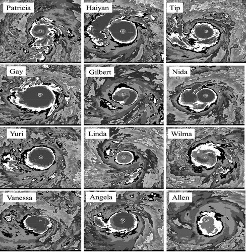
Figure 1. Infrared satellite images of the twelve strongest tropical cyclones from 1979 – 2017, enhanced for use with the Dvorak satellite intensity estimation technique. The storms are all shown at their respective maximum intensities, remapped to a common projection and scale. Credit: Velden et al. 2017, Reprocessing the Most Intense Historical Tropical Cyclones in the Satellite Era Using the Advanced Dvorak Technique, Monthly Weather Review (American Meteorological Society)
Lots of uncertainty with satellite estimates of tropical cyclone intensity
There is a lot of uncertainty about just how strong Halong was, though, since its intensity was estimated purely from satellite data. The best estimates of tropical cyclone strength come from the Hurricane Hunters. Their aircraft fly directly into storms and can make three independent measurements of the winds: with flight-level wind instrumentation, with dropsondes that fall to the surface, and from stepped frequency microwave radiometer (SFMR) observations of the roughness of the ocean surface. All of these measurement techniques are subject to errors, and an aircraft does not sample the whole storm. Thus, errors in measuring the peak intensity of a tropical cyclone of at least 5 mph are to be expected, and errors of 10 mph are probably common.
Unfortunately, the Hurricane Hunters regularly fly only in the Atlantic, with a few missions in the Northeast Pacific for hurricanes that threatens Mexico, Central America, or Hawaii. Regular hurricane hunter missions by the U.S. Air Force in the Northwest Pacific ended in 1987, and there have never been regular hurricane hunter missions done over the rest of the world’s oceans. All of these regions rely on satellite-only estimates of intensity.
The method used to estimate tropical cyclone intensity using satellites is called the Dvorak technique, developed by Vernon Dvorak in 1975. The method relies on expert subjective human analysis of characteristic cloud patterns, and generates a tropical number (T-number) that ranges from 1.0 for a tropical depression with 29 mph winds to 8.0 for a category 5 storm with 196 mph winds. Note that this upper limit presents a problem, since we know that tropical cyclones can have winds of at least 215 mph. That’s the intensity 2015’s Hurricane Patricia attained off the Pacific coast of Mexico, as measured by the Hurricane Hunters. If we had had only satellite measurements of Patricia, it would have been difficult to justify assigning an intensity greater than 196 mph.
The Dvorak technique is not always consistently applied from one specialist to the next, or one forecast office to the next, or one hurricane season to the next. Comparison with wind measurements from the hurricane hunters shows that satellite-estimated winds using the Dvorak method do surprisingly well, differing by 5 mph or less about 50% of the time, and by less than 13 mph or less about 75% of the time. Differences of 20 mph or more occur about 10% of the time, though.
To avoid the problems associated with subjective human application of the Dvorak technique, a computer-automated version of the method calibrated using hurricane hunter data, called the Advanced Dvorak method, was developed beginning in 1998 by a team of scientists led by Chris Velden and Timothy Olander of the University of Wisconsin Cooperative Institute for Meteorological Satellite Studies (CIMSS). Their objective Advanced Dvorak Technique (ADT) is fully automated and runs in real time, generating a T-number one can compare with the subjective Dvorak technique estimates given by groups like the JTWC. Unlike the subjective Dvorak technique estimates, which produce T-numbers in increments of 0.5 with a cap at 8.0, the ADT T-numbers have a resolution in increments of 0.1, and can exceed 8.0. The peak ADT intensity for Halong was T7.9, making it the 8th strongest tropical cyclone on record since accurate satellite measurements began in 1979.

Figure 2. The strongest storms for the major ocean regions that see high tropical cyclone activity, as rated using the Advanced Dvorak Technique (ADT) described in Velden et al. 2017, Reprocessing the Most Intense Historical Tropical Cyclones in the Satellite Era Using the Advanced Dvorak Technique. Of the seven regions, five had their strongest storm on record in the past six years. Hurricane Patricia (2015) in the Northeast Pacific ranks as the strongest storm in any basin during the period of analysis, followed by Northwest Pacific’s Typhoon Haiyan (2013), Typhoon Tip (1979), and Typhoon Gay (1992). Hurricane Gilbert (1988) is ranked just ahead of Hurricane Allen (1980) and Hurricane Wilma (2005) for the Atlantic basin crown. In the north Indian Ocean basin, Tropical Cyclone Paradip (1999) edges out Tropical Cyclone Sidr (2007), while in the south Indian Ocean, Tropical Cyclone Gafilo (2004) ranks as the most intense. In the Australian region, Tropical Cyclone Monica (2006) is classified as the strongest event while in the southeast Pacific basin, Tropical Cyclone Pam (2015) edges out Tropical Cyclone Winston (2016). A tie of two storms with equally strong winds in the South Indian Ocean was resolved by selecting the storm with the lower central pressure Fantala (2016). Hurricane Irma in the open Atlantic was added by personal communication with the paper’s main author, Chris Velden. Image was taken from the 2018 RealClimate.org post, Does global warming make tropical cyclones stronger? Credit: Graphing by Stefan Rahmstorf; background image by Robert Rohde(CC BY-SA 3.0)
Are the strongest tropical cyclones getting stronger?
Theory suggests that a warming climate should make the strongest tropical cyclones stronger, since hurricanes are heat engines that extract heat energy from the oceans, converting it to kinetic energy in the form of wind. Due to the uncertainties involved with applying the Dvorak technique in regions where we do not have hurricane hunter data, plus the relatively short period of time that we have satellite data for, it is not yet certain that we are seeing an increase in intensity of the strongest storms due to human-caused climate change (though many research papers are finding evidence of this--see my list of related posts at the end of this article).
In a 2019 Review Paper by 11 hurricane scientists, “Tropical Cyclones and Climate Change Assessment: Part I. Detection and Attribution”, ten of 11 authors concluded that the balance of evidence suggests that there is a detectable increase in the global average intensity of global hurricanes since the early 1980s; eight of 11 authors concluded that the balance of evidence suggests that human-caused climate change contributed. All 11 authors agreed that the balance of evidence suggests that the proportion of all hurricane reaching Category 4-5 strength has increased in recent years; eight of 11 authors concluded that the balance of evidence suggests that human-caused climate change contributed.
A 2017 paper by the developers of the ADT, Reprocessing the Most Intense Historical Tropical Cyclones in the Satellite Era Using the Advanced Dvorak Technique, took a look back at the strongest tropical cyclones on record since accurate satellite data began in 1979 (except for the Indian Ocean, where accurate data began in 1998). The list of strongest tropical cyclones using the ADT was different than the official “best track” ratings, since that rating system uses data with a time resolution of once every six hours. A storm often reaches its peak intensity between these 6-hourly times, and the ADT can generate an intensity rating as often as satellite imagery is available—up to every 30 minutes. Using a consistent method with imagery from geostationary satellites that was of the same resolution for every storm, their ADT ratings, shown in the table above (adjusted using measurements from the Hurricane Hunters), found that five of the top thirteen strongest tropical cyclones during the 41-year satellite record occurred during the most recent 20 years (in an email, Chris Velden confirmed that this week’s Super Typhoon Halong was part of this list). Eight of the record-strength storms occurred during the initial 20-year period (1979 - 1998).
Thirteen storms is not a large enough sample size to make any conclusions with, but this result by itself does not suggest that record-strength tropical cyclones are growing more common. More eye-opening is the fact that in five of the seven major ocean regions that see high tropical cyclone activity, the strongest storm on record has occurred in the past six years (Figure 2). This year may see a new addition to the list: in an email, Chris Velden said that it was possible that Hurricane Dorian, which ravaged The Bahamas with 185 mph winds in September of this year, might end as the strongest hurricane ever recorded in the open Atlantic (outside of the Caribbean and the Gulf of Mexico)--once the National Hurricane Center comes out with their post-season analysis of the storm in 2020. The current record holder is Hurricane Irma of 2017 (180 mph winds).
Related posts:
Bob Henson has more on background and links to imagery for Typhoon Halong in a November 5 post on the Category 6 blog at Weather Underground.
Hurricane Dorian Was Worthy of a Category 6 Rating, my October 2019 post.
Protective Wind Shear Barrier Against Hurricanes on Southeast U.S. Coast Likely to Weaken in Coming Decades, my June 2019 post.
Highly Unusual Upward Trends in Rapidly Intensifying Atlantic Hurricanes Blamed on Global Warming, my February 2019 post.
Dangerous Rapidly Intensifying Landfalling Hurricanes Like Michael and Harvey May Grow More Common, my October 2018 post.
Extreme Hurricane Rainfall Expected to Increase in a Warmer World, my June 2018 post.
Observed Slowdown in Tropical Cyclone Motion May Portend More Harvey-Like Rainstorms, my June 2018 post
Will Global Warming Make Larger Hurricanes?, my April 2018 post.
Will Global Warming Make Hurricane Forecasting More Difficult?, my January 2017 post.
Top Ten Tropical Cyclone Events of 2016 Potentially Influenced by Climate Change, my December 2016 post.
Extreme 'Grey Swan' Hurricanes in Tampa Bay: a Potential Future Catastrophe, my July 2016 post.
Hurricane Patricia's 215 mph Winds: A Warning Shot Across Our Bow, my 2016 post.
Katrina-Level Storm Surges Have More Than Doubled Due to Global Warming, my 2013 post.
Damaging Katrina-Level Storm Surges are Twice as Likely in Warm Years, my 2012 post.
Big Money for Hurricane Research, my October 2006 post.