This article was published in Scientific American’s former blog network and reflects the views of the author, not necessarily those of Scientific American
Category 5 Atlantic hurricanes are rare. Only 7% of the 243 hurricanes observed since accurate satellite measurements began in 1983 have reached that catastrophic intensity. And it is truly exceptional to see a category 5 hurricane as strong as Hurricane Dorian, which powered ashore on Great Abaco Island in The Bahamas on September 1, 2019, with sustained winds of 185 mph and gusts up to 220 mph. Winds of this strength would make Dorian worthy of a category 6 rating, if it existed. (For those of you unfamiliar with me, know that there is already a Category 6—it’s the name of a blog I co-author with Bob Henson over at Weather Underground, specializing in daily updates of global tropical cyclone activity).
The Saffir-Simpson Hurricane Wind Scale, which is used to rank hurricane winds on a scale of one to five, stops at category 5: sustained 1-minute average wind speeds of at least 157 mph (70 m/s). If we were to add a category 6 to the scale, we must consider that the scale is not quite linear. Winds for a category 2 hurricane span a range of just 15 mph, for example, but winds for a category 4 storm span a range of 27 mph. Regardless of this non-linearity, a one-category increase in intensity on the scale results in approximately four times more wind damage, according to the National Hurricane Center.
If we graph the scale (Figure 1 below), it is apparent that a category 6 should probably start at winds of 180 - 185 mph. A category 7 hurricane would have winds of at least 210 - 215 mph. By this logic, Hurricane Dorian would rate as a category 6 hurricane. Only one hurricane in world history would rank as a category 7: Hurricane Patricia of 2015, which peaked with 215-mph sustained winds off the Pacific coast of Mexico.
On supporting science journalism
If you're enjoying this article, consider supporting our award-winning journalism by subscribing. By purchasing a subscription you are helping to ensure the future of impactful stories about the discoveries and ideas shaping our world today.

Figure 1. A hypothetical extended Saffir-Simpson Hurricane Wind Scale, which includes a category 6 and category 7. Credit: Jeff Masters, with inspiration from Stefan Rahmstorf
If one uses 185-mph winds as the threshold for category 6, only five Atlantic hurricanes in recorded history would qualify. If we lower the threshold to 180 mph, there are a total of eight that would rate as a category 6:
190 mph: Allen 1980
185 mph: Dorian 2019, Labor Day 1935, Gilbert 1988, Wilma 2005
180 mph: Mitch 1998, Rita 2005, Irma 2017
It is truly rare for a hurricane of this hypothetical category 6 intensity to make landfall. Dorian’s 185-mph winds over Great Abaco and Grand Bahama islands tied it with the 1935 Labor Day hurricane in the Florida Keys as the strongest landfalling Atlantic hurricane on record. Expanding the definition of category 6 to include winds of 180 mph or higher would add just one additional Atlantic landfalling category 6 hurricane: Hurricane Irma of 2017, which made landfall on Barbuda, St. Martin, and the British Virgin Islands with maximum sustained winds of 180 mph.
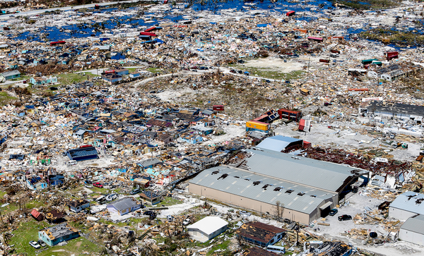
Dorian caused catastrophic damage, thanks in great part to its very slow motion of less than 5 mph over The Bahamas for the 27 hours it spent at category 5 strength. This slow motion and extreme intensity allowed Dorian to subject The Bahamas to the most fierce and prolonged battering by an Atlantic hurricane of any populated place in recorded history. Preliminary damage estimates in The Bahamas are $7 billion—over 50% of their $12 billion GDP. The death toll as of this writing is 56, with approximately 600 people still missing.

Figure 2. Category 5 Hurricane Dorian over Grand Bahama Island on September 2, 2019.Credit: NOAA
Should the Saffir-Simpson scale be expanded to include a category 6?
Unfortunately, global warming is making ultra-intense hurricanes like Dorian more likely to occur (a subject I will take up in a future post). Thus, it makes sense from a climate change communication point of view to expand the Saffir-Simpson scale to include a category 6—and category 7—to call attention to this new breed of ultra-intense catastrophic hurricanes that will likely grow increasingly common in the coming decades. Since there would be so few of these category 6 and 7 hurricanes, though, it would be difficult to do any kind of meaningful statistical study of how they might be changing with the changing climate.
Any move to expand the Saffir-Simpson scale would have to come from the National Hurricane Center (NHC), though, and there is little support for such a move from the experts there. From a public safety/warning standpoint, NHC experts I’ve heard from believe that including a category 6 would do little good, since a category 5 hurricane is already considered catastrophic. In the continental U.S., for example, there have only ever been four category 5 hurricanes to make landfall (in 1935, 1969, 1992, and 2018). News that a category 6 storm was heading towards them would probably not motivate people to take action to protect lives and property any more than if a category 5 storm was coming.
Should the Saffir-Simpson scale be replaced?
Some hurricane experts believe that the Saffir-Simpson scale should be scrapped entirely. The original scale, introduced in 1971, included both wind speeds and typical storm surge for each category. Over time, it became apparent that the magnitude of the storm surge threat often did not correlate well with a hurricane’s Saffir-Simpson category. For this reason, NHC removed the storm surge values in 2010, resulting in a wind-only scale.
A big problem remains: most of the loss of life in hurricanes is from water—storm surge and freshwater flooding—not from wind. We need to come up with a system that alerts people in a concise way of the magnitude of the threat to life and property due to winds, storm surge, and inland flooding, and not just the magnitude of the winds.
With this in mind, NHC made storm surge watches and warnings operational during the 2017 hurricane season. However, these storm surge advisories do not give quantitative measures of storm surge or its potential damage. A better solution might be the introduction of a storm surge scale. One such scale, named the Kuykendall scale or K scale, was proposed in 2018 by Penn State scientists Amanda Walker and David Titley. The logarithmic basis of the scale, which runs from zero to ten, makes communication of the scale’s meaning straightforward: every integer increase in K leads to a tenfold increase in per capita damage losses. RMS.com has another way to quantify storm surge damage potential, using Integrated Kinetic Energy (IKE), that is also promising.
But this still leaves us without a good way to communicate the inland flooding threat from a slow-moving hurricane that dumps catastrophic amounts of rainfall. Unfortunately, this threat is growing, since the forward speed of tropical cyclones (which includes all hurricanes, tropical storms, and tropical depressions) has decreased globally by about 10% since 1949, according to a 2018 paper in the journal Nature by NOAA hurricane scientist Dr. Jim Kossin. As a result of their slower forward motion, tropical cyclones are now more likely to drop heavier rains, increasing their flood risk. Heavy rains are also increasing due to the extra amount of moisture that evaporates into the air due to global warming. category 4 Hurricane Harvey in Texas/Louisiana in 2017 ($128 billion in damage) and category 1 Hurricane Florence in the Carolinas in 2018 ($24 billion in damage) were both examples of slow-moving storms whose fresh-water flood risk was not adequately represented by their Saffir-Simpson rating. So, perhaps a new scale for inland flood risk is needed.
Local National Weather Service offices already provide detailed, color-coded maps that show the relative threat levels from four different hurricane hazards: winds, storm surge, flooding rains, and tornadoes. But having three separate scales for the risk from wind, storm surge, and rainfall might be too complicated for many people to digest. Some nations in Europe have a simple system of yellow, orange and red alerts that convey the magnitude of storm threat; perhaps that should be used for hurricanes. That may be too simple, but we need something different than the current system.