This article was published in Scientific American’s former blog network and reflects the views of the author, not necessarily those of Scientific American
There had been warnings that Anak Krakatau, the restless young volcano rising like a phoenix from the remains of its predecessor, was in a particularly dangerous mood. It had been in a vigorous eruptive phase since June of 2018, sometimes imperiling boats passing near it in the Sunda Strait. But Indonesians were quite used to the tantrums thrown by their problem child. Life went on as usual. After all, nothing the child could do would match the catastrophe caused by its parent volcano, which had destroyed itself in August of 1883, killing nearly 40,000 people.
So when the eruptive activity abruptly increased on December 22nd, no one expected much in the way of disaster.
As the Volcanological Survey of Indonesia recorded 423 separate events from noon until 6 pm, and raised the warning to Level II, authorities advised citizens and visitors to remain at a prudent 2 kilometer distance, but otherwise didn't see the cause for undue alarm.
On supporting science journalism
If you're enjoying this article, consider supporting our award-winning journalism by subscribing. By purchasing a subscription you are helping to ensure the future of impactful stories about the discoveries and ideas shaping our world today.
Here is the fearsome truth about volcanoes: no matter how well we know them (and we'd known Anak Krakatau since it was born), no matter how well we monitor them (and this one has been continuously monitored since 1980), they can still take us by surprise. There are some events even the best monitoring can't detect or predict in time to provide adequate warning. This was the case at 9:03 pm on December 22nd, when an explosion knocked out the seismometers closest to the volcano, and the weakened, oversteepened and overburdened southwest sector of the cone collapsed into the sea.
No one watching the volcano knew this had happened. Other seismometers picked up tremors, but they had been doing so all day. None of the quakes caused by the collapse were large enough to set off tsunami warnings. When two thirds of the cone hit the sea, there were no sensors that could detect the massive waves of displaced water that surged away from the island.
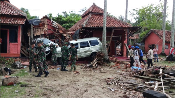
It was a miniature version of the devastating 1883 tsunami sequence. And no one knew it was happening until the first waves hit nearly half an hour later. In minutes, relentless waters rolled over the coastlines and surged inland. Houses were demolished, boats and cars wrecked, families and friends ripped from each other, and over four hundred people killed. Thousands more lost everything but their lives. And at first, no one understood why, or how, or could guess whether it would happen again.
In those early days, there was a scramble to figure out why the disaster had happened, and the actual scale of it. Excellent overviews were published at Rocky Planet, Magma Cum Laude, and Forbes. Some publications investigated why the early warning systems didn't work, and why it's nearly impossible to make networks that do work for this sort of thing. Some tentative explanations were offered.
Survivor stories described the terror of being caught up in a sudden tsunami. A particularly grim moment happened when waves struck a beachside concert, sweeping away fans and band alike.
On December 23rd, we got the first visual confirmation that a substantial portion of the volcano had collapsed. It's one thing to know that there must have been a collapse; it's quite another to begin to realize the scale of it.
Over the next few weeks, the scale of the disaster became clear. Several news articles and blogs analyzed images and information, coming to some very sobering conclusions. We discovered how much the volcano had changed, what that change did to the style of eruption, and the mechanisms behind the tsunami. We also saw just how dramatically the volcano changed in the few short weeks after the eruption. There's a lot here, so let's have a list instead of inline links:
Anak Krakatau: Indonesian volcano's dramatic collapse
Anak Krakatau volcano: Satellites get clear view of collapse
First visual satellite images of Anak Krakatau show the enormous extent of the landslide
Anak Krakatau: Planet Labs imagery of the aftermath of the landslide
Satellite Images Show Shattered Remains of Indonesia’s Tsunami-Causing Volcano
Spectacular aerial video of Anak Krakatoa now with crater lake
Anak Krakatau: Finnish radar satellite eyes tsunami volcano
This Is What Those New Satellite Images Of Anak Krakatau Are Showing
You may wonder how this sector collapse compares to the most massive volcanic landslide in recorded history. Dr. Janine Krippner helpfully compared Anak Krakatau to Mount St. Helens, and there's definitely a difference in size! The baby volcano, while massive, couldn't compete with the robust Washington adolescent.
This disaster may have seemed like it came out of nowhere, but back in 2012, a paper was published advising that a landslide and subsequent tsunami at Anak Krakatau was almost inevitable. One of the authors, Thomas Giachetti, explained their research in some detail, and advised why the volcano, reduced as it is, is still dangerous.
Modeling this tsunami can help us prepare for volcanic tsunami hazards to the United States – including in some areas you might not expect to be at risk.
For extensive posts on the Anak Krakatau tsunami, I highly recommend the following:
The Child of Krakatoa Awakes on the Earth Observatory Blog has spectacular images and clear explanations of the volcano's behavior and why volcanic tsunamis are a terrible challenge.
Photographer Øystein Lund Andersen wrote a remarkable eyewitness account: Krakatau volcano: Witnessing the eruption, tsunami and the aftermath 22-23th December 2018. The extensive images accompanying his harrowing text give us an unparalleled look at the tsunami and its effects.
You can find a general explanation of what tsunamis are here, and an excellent description of volcanic tsunamis here.
So, what should you do if you're caught in an area where a volcanic tsunami is possible? Dr. Krippner has some sound advice:
If you see unusual activity, like larger than usual waves, it is okay to make the decision to take action by evacuating. Basically - if you see unusual ocean activity, it is okay to run like hell.
This is what saved Andersen's life. From his account:
So while contemplating about this, suddenly I noticed that a odd incoming wave appear in the ocean in front of me, much higher than normal. (Time now is between 21:27-21:28.) . I realize quite fast that this wave will make it over the sandy beach to my position. (I was standing 10-12m inland from the edge of the ocean, 3m behind the edge of the beach). I grab my camera that is standing on a tripod and run inland trough the bushes. The terrain was gentle uphill. I look back when I had ran maybe 15m, and I see the wave had passed the beach and is still coming towards me but with decreased speed. Next time I turn back, I see the wave stop at about 15m inland from the edge of the beach. I stop for a brief moment, and I realize that this could not have been a normal wave.
Fast, decisive action can be the difference between living and dying. You can learn more about the warning signs for various types of tsunamis here.
Do you want to help? The Red Cross and Doctors Without Borders are both great choices. And there are other agencies that are on the ground helping people put their lives back together. Just remember to verify it's legit before donating to any individual or organization.