This article was published in Scientific American’s former blog network and reflects the views of the author, not necessarily those of Scientific American
There are many ways to approach Mount St. Helens. The west side is probably the best known, and definitely one of the most dramatic experiences you can have on the mountain. It's also quite well-developed, which makes for great travels and souvenir-acquiring. And the east side, I hear, has some spectacular views of the blast zone - we'll check that out together next year! For volcano viewing, those are two excellent approaches to our iconic mountain.
The south side sustained much less damage in the May 18, 1980 eruption. Its forests are mostly intact. Mount St. Helens is only visible from a view places, and you can't see her immense crater - the only sign that something is rather odd about this volcano is how flat and broad her top is. But there are some really neato volcanic features to visit. You've probably already heard about Ape Cave, a lava tube in a flow that happened around 2,000 years ago. That same lava flow buried a forest, leaving tree casts that the more slender and adventurous among you can squeeze through. There's also plenty of hawt May 18th, 1980 action: you can stand on the plain created by a huge lahar, hike a canyon scoured by one branch of it, and visit a maclargehuge erratic boulder deposited by another.
Today, we're going to visit another unexpected gift of the lahar that poured from Shoestring Glacier that morning. We'll see 13,000 years of volcanic havoc laid gloriously bare. To get there, we'll pass the Lahar Viewpoint, and pull over just before the bridge over the Muddy River. There's a trail that takes off through the young trees, winding a narrow way over fresh volcanic ash and rock, past carpets of moss, and emerging on the bank of a wide channel filled with rocks and boulders. Mount St. Helens looms just beyond.
On supporting science journalism
If you're enjoying this article, consider supporting our award-winning journalism by subscribing. By purchasing a subscription you are helping to ensure the future of impactful stories about the discoveries and ideas shaping our world today.
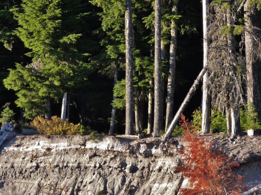
All those lovely rocks in the river bed are bits and chunks of Mount St. Helens. There's pieces and parts of her from all throughout her past, brought down from her cone by powerful flows of mud and water.
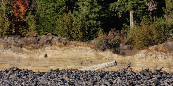
Look to the opposite bank, and you see a gorgeous exposure of various layers in shades of yellow, tan, and brown.

If you like your stratigraphy, this is about where you start to salivate a lot.
The cliff there is 20 feet tall in places, and was carved out by the lahar and floods that pounded down this river drainage on May 18th, 1980 and more events since. We can see an appreciable chunk of Mount St. Helens's eruptive history in that bank, from 13,000 years ago right up to that cataclysmic May morning. There are at least twelve total layers, although some are hard to see even up close. If you get your nose up against it, you're going to discover five layers of airfall tephra (ash and pumice that fell like lithic rain from eruption clouds), three pyroclastic flow layers (ash and pumice layers that sometimes contain wood ripped up and charred by the flows' superheated gasses), two lahar layers (including one from May 18th), and two soil layers. Here's a very rough guide to some of the major divisions within one portion of the bank:
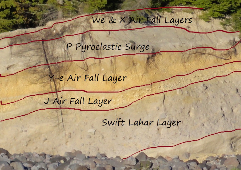
The 1980 lahar deposits are a thin veneer across the top. As you can see, despite how momentous that eruption seemed to us, it's not the biggest volcanic event this place has seen. There's been plenty of excitement down this way.
If you cross the river and inspect the bank closely, you'll find narrow layers that can't be viewed from a distance. Alas, my friend Funny Diva and I arrived rather late in the day and didn't get a chance to traipse over there. All of my views are from a distance. We'll try to get a closer look next year.
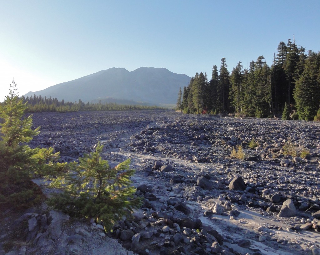
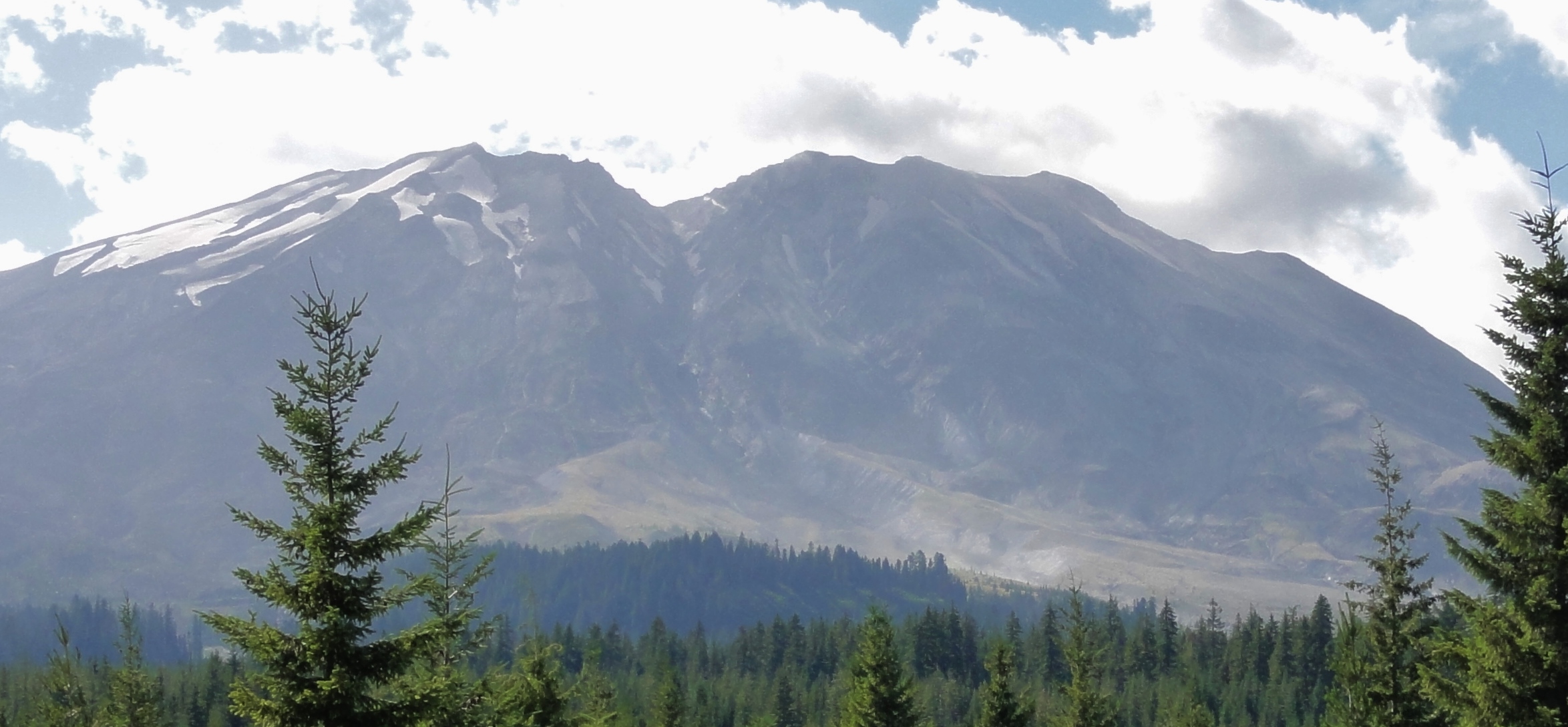
Let's talk about the lahar that carved here and veneered there and thus gave us this lovely display of volcanic art. Alas, it was my fate to only arrive at this area late in the day this year, but there's some slightly better lighting for our purposes in this photo taken from the Lahar Viewpoint this year.
That broad trough coming from the notch in the middle was carved by Shoestring Glacier. That's a pretty spectacular glacial trough! And what's even more impressive is that even in our warm modern times, the glacier used to nearly fill it. It's dwindling is a volcanic story, although our warming climate isn't doing it any favors.
We're very fortunate that glaciologist Melinda Brugman had been studying it shortly before the May 1980 eruption, because her data allowed us to measure the effect all that volcanic mayhem had on it. The poor thing was 1,300 longer before 8:32 am on May 18th. It got beheaded when the summit collapsed. Seconds later, a pyroclastic flow surged down it. Look at the length of that trough: even decapitated, it's about three miles long. The pyroclastic flow took only 90 seconds to get to its base. It melted almost 30 feet of ice and snow from the glacier's surface. All that meltwater mixed with ash, rock, and assorted debris, and hurtled downslope at about 60 miles per hour.
Just imagine this thing thundering down the mountain. It's the consistency of concrete and traveling at highway speeds, ripping up trees as it goes. It's got huge rocks, some of them the size of cars, being rafted on its surface. By the time it's reached us here at the Stratigraphy Viewpoint, it's slowed to 45 miles per hour, but it's 15 feet deep and a bridge-eating monster. It strips some trees, leaving them looking like bayonets. Boulders carried by it bash the trunks of others, stripping off bark. You can still see some of the scars, although young growth makes them hard to spot.
Near here, the lahar splits. One branch heads down the Pine Creek drainage, while the rest of it continues down the Muddy River and scours Lava Canyon to bedrock. I used to think of lahars as big muddy streams that mostly deposited lots of stuff, but they have tremendous erosional power, too.
By 9:00 am, when it spills into Swift Reservoir downstream, it's killed two bridges. Seventeen million cubic yards of debris raises the level of the reservoir two and a half feet in seconds. The only reason the Lewis River valley and communities downstream don't experience catastrophic flooding is because of volcanologists like Dwight Crandall and Donal Mullineaux, who studied volcanic deposits much like the ones exposed here in the riverbanks and said, "You know, chances are pretty darned good we're going to get lahars down these drainages during a major eruption. Let's just lower those reservoirs to prevent huge floods, then, shall we?"
This is why we stick our noses in these lovely bits of exposed strata, my darlings. It's not just for the sheer delight of learning a volcano's history. It's so that we can better understand what she's done in the past so we can figure out what she might do in the future. An active volcano is a hazardous thing to have around our civilizations, but we can learn how to live with her a bit more safely.

Stratigraphy Viewpoint is already training generations of future volcanologists. It's an excellent place to get some perspective - and get an eye-full of nature's explosive artwork.
References:
Kuehn, Stephen C. (2014): Tephra 2014 Guide: Field Trip to Mt. St. Helens.
Lipman, Peter W., and Mullineaux, Donal R., Editors (1981): The 1980 Eruptions of Mount St. Helens, Washington. U.S. Geological Survey Professional Paper 1250.
Pringle, Patrick T. (2002): Roadside Geology of Mount St. Helens National Volcanic Monument and Vicinity. Washington DNR Information Circular 88.
USFS (2003): Strata Stories.