This article was published in Scientific American’s former blog network and reflects the views of the author, not necessarily those of Scientific American
A few years ago, I was enchanted with the Venn diagram explorations published by EleVR, a now shuttered virtual reality startup helmed by M Eifler, Vi Hart, and Andrea Hawksley. They wrote about a making a virtual Venn diagram museum, a Venn diagram house, and even a Venn digram piano. Their post about Venn diagrams in light reminded me that color theory is mind-blowing!
Since I read those posts, I have been thinking about unions and intersections in other aspects of life, including on maps. For your edification and/or delight, I present some intersected states of America. Each map shows the states that satisfy one or both of two different traits. Solid colors indicate the states that satisfy one trait, stripes indicate states that satisfy both. If the image is not accessible to you, the text below each map lets you know which states are shaded which colors for which reason. I’ve included my information sources in the map captions as well. These maps are just for fun, so I considered Wikipedia-type sources sufficient and did not do a lot of extra work verifying each item. If you need any of this information for more serious purposes, I encourage you to verify it using more reliable sources.
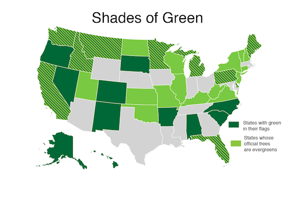
Credit: Evelyn Lamb, based on Theshibboleth Wikimedia (CC BY-SA 3.0); Sources:
https://en.wikipedia.org/wiki/Flags_of_the_U.S._states_and_territories and
https://en.wikipedia.org/wiki/List_of_U.S._state_and_territory_trees
On supporting science journalism
If you're enjoying this article, consider supporting our award-winning journalism by subscribing. By purchasing a subscription you are helping to ensure the future of impactful stories about the discoveries and ideas shaping our world today.
*States shaded in dark green to show that an evergreen is their state tree: Alabama, Alaska, Arkansas, Colorado, Hawaii, New Mexico, North Carolina, Oregon, South Carolina, South Dakota
States shaded in light green to show that there is green in their flag: Connecticut, Illinois, Kansas, Kentucky, Missouri, New Hampshire, New Jersey, New York, North Dakota, Oklahoma, Utah, Vermont, Virginia, West Virginia, Wisconsin
States that are striped to show both are true: California, Delaware, Florida, Idaho, Maine, Michigan, Minnesota, Montana, Nevada, Pennsylvania, Washington
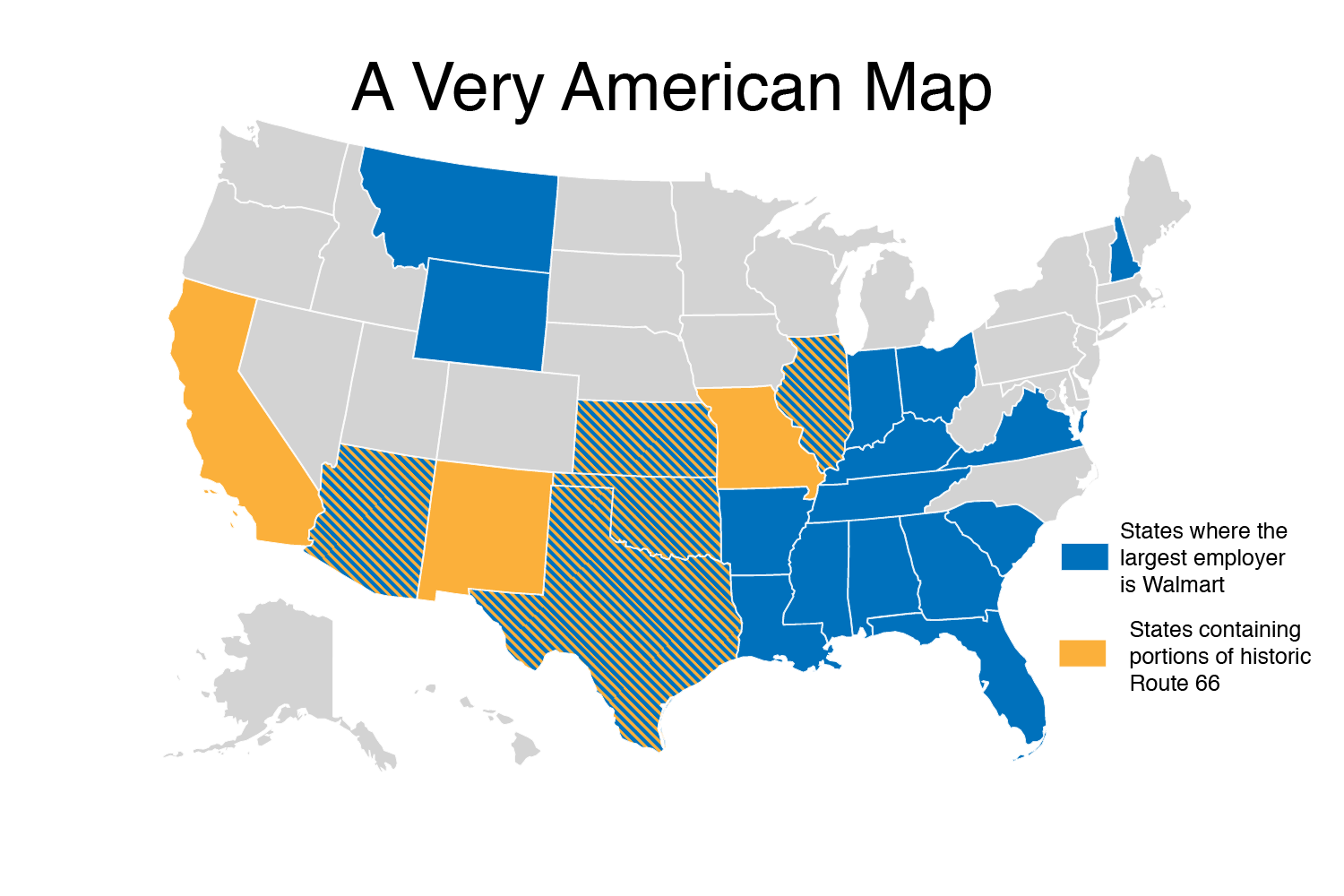
Credit: Evelyn Lamb, based on Theshibboleth Wikimedia (CC BY-SA 3.0); Sources: https://en.wikipedia.org/wiki/U.S._Route_66 and
https://www.businessinsider.com/largest-employers-each-us-state-2017-6
States shaded in yellow to show that historic route 66 went through them: California, Missouri, New Mexico
States shaded in blue to show that the largest employer is Walmart: Alabama, Arkansas, Florida, Georgia, Indiana, Kentucky, Louisiana, Mississippi, Montana, Ohio, South Carolina, Tennessee, Vermont, Virginia Wyoming
States that are striped to show both are true: Arizona, Illinois, Nebraska, Oklahoma, Texas
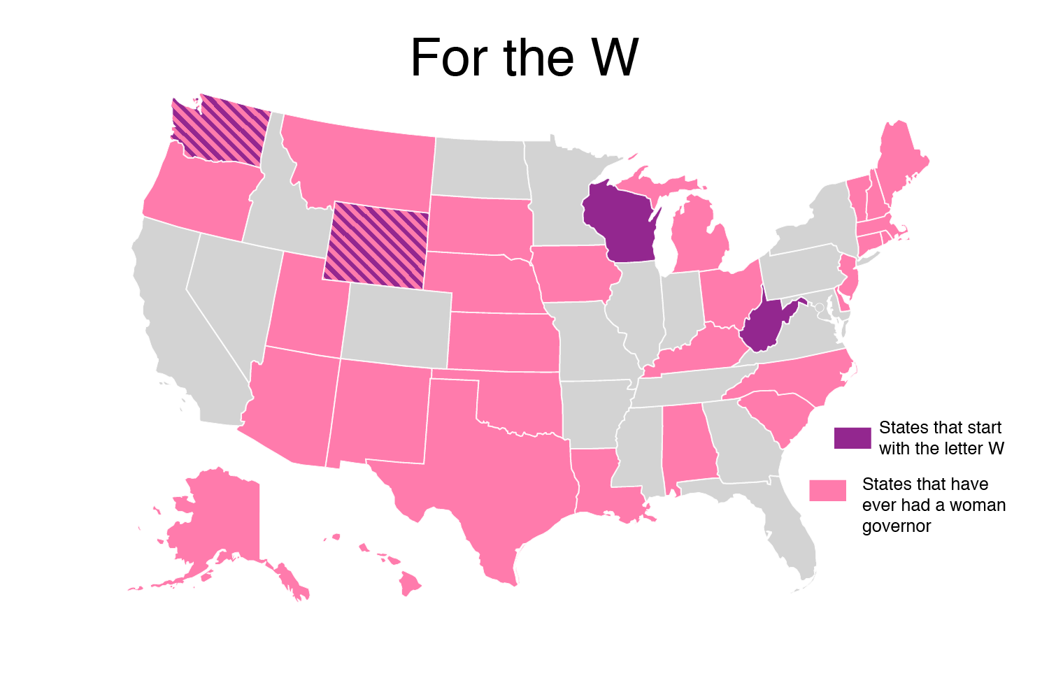
Credit: Evelyn Lamb, based on Theshibboleth Wikimedia (CC BY-SA 3.0); Source: https://en.wikipedia.org/wiki/List_of_female_governors_in_the_United_States
States shaded in magenta because they start with a W: West Virginia, Wisconsin
States shaded in pink because they have had women as governors: Alabama, Alaska, Arizona, Connecticut, Delaware, Hawaii, Iowa, Kansas, Kentucky, Louisiana, Maine, Massachusetts, Michigan, Montana, Nebraska, New Hampshire, New Jersey, New Mexico, North Carolina, Ohio, Oklahoma, Oregon, Rhode Island, South Carolina, South Dakota, Texas, Utah, Vermont
States that are striped to show both are true: Washington, Wyoming
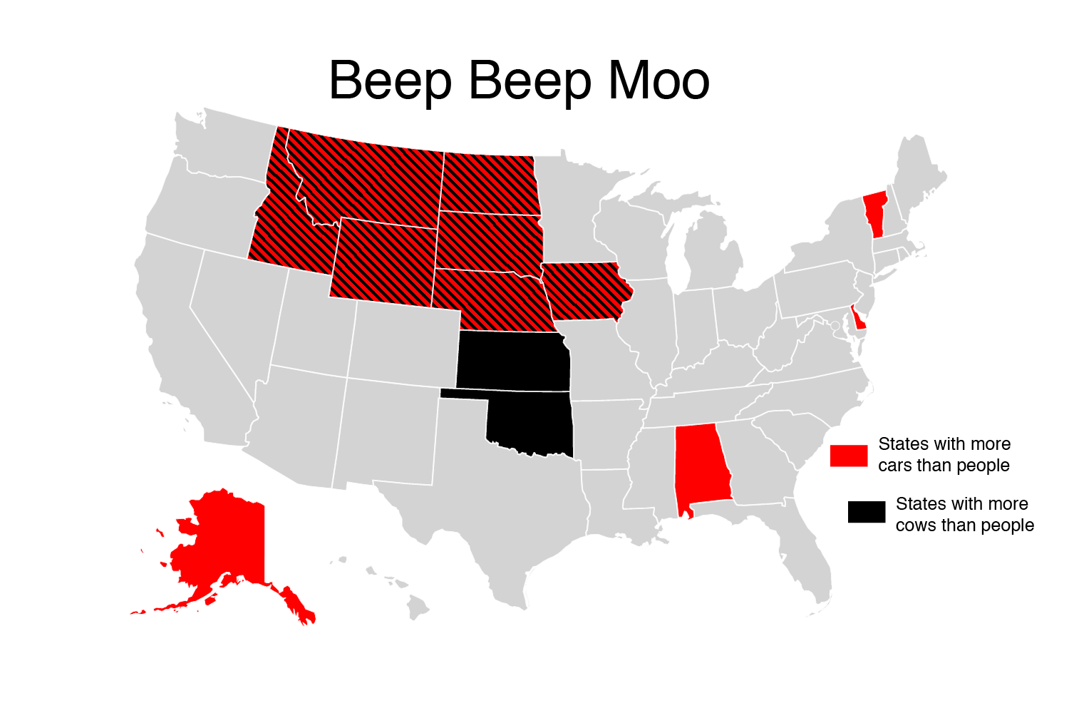
Credit: Evelyn Lamb, based on Theshibboleth Wikimedia (CC BY-SA 3.0); Sources: https://beef2live.com/story-cattle-inventory-vs-human-population-state-0-114255 and https://en.wikipedia.org/wiki/List_of_U.S._states_by_vehicles_per_capita
States that are shaded red because there are more cars than people: Alabama, Alaska, Delaware, Vermont
States that are shaded black because there are more cows than people: Kansas, Oklahoma
States that are striped because both are true: Idaho, Iowa, Montana, Nebraska, North Dakota, South Dakota, Wyoming
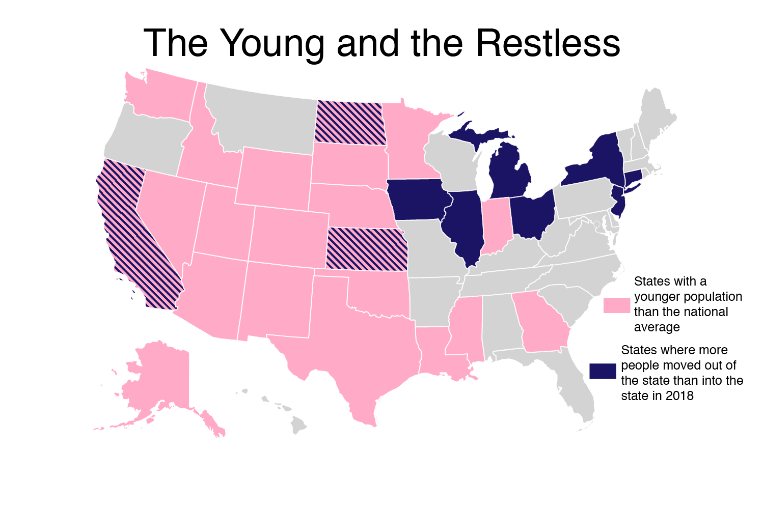
Credit: Evelyn Lamb, based on Theshibboleth Wikimedia (CC BY-SA 3.0); Sources: https://www.unitedvanlines.com/newsroom/movers-study-2018 and https://en.wikipedia.org/wiki/List_of_U.S._states_and_territories_by_median_age
States shaded light pink to show their population is younger on average than the median age of the country: Alaska, Arizona, Colorado, Georgia, Idaho, Indiana, Mississippi, Nebraska, Nevada, New Mexico, North Dakota, Oklahoma, South Dakota, Texas, Utah, Washington, Wyoming
States shaded dark purple to show that more people moved out of them than in in 2018: Connecticut, Illinois, Iowa, Michigan, New Jersey, New York, Ohio
States that are striped to show both are true: California, Kansas, North Dakota
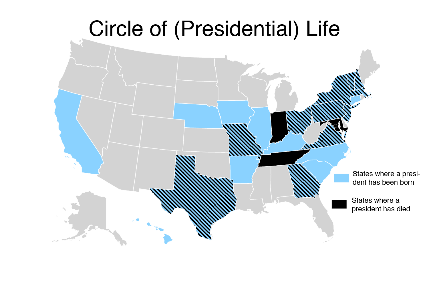
Credit: Evelyn Lamb, based on Theshibboleth Wikimedia (CC BY-SA 3.0); Sources: https://en.wikipedia.org/wiki/List_of_presidents_of_the_United_States_by_home_state#Birth_places and https://en.wikipedia.org/wiki/List_of_presidents_of_the_United_States_by_date_of_death
States that are shaded blue because a President was born there: Arkansas, California, Connecticut, Hawaii, Illinois, Iowa, Kentucky, Nebraska, North Carolina, South Carolina
States that are shaded black because a President died there: Indiana, Maryland, Tennessee, Washington D.C.
States that are striped to show both are true: Georgia, Massachusetts, Missouri, New Hampshire, New Jersey, New York, Ohio, Pennsylvania, Texas, Vermont, Virginia
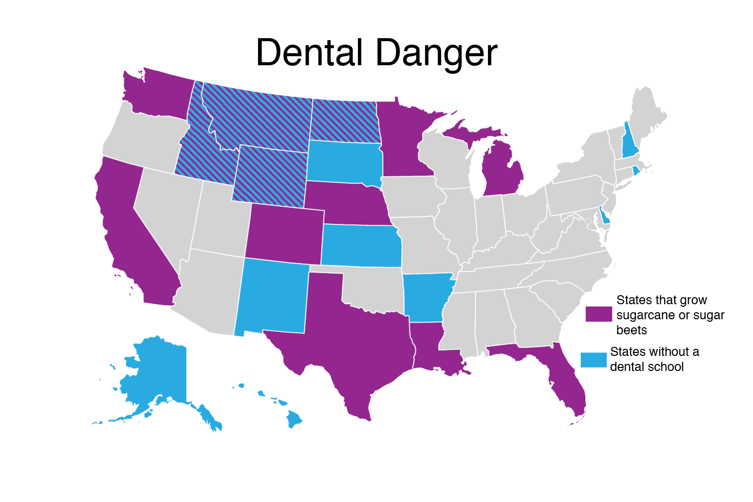
Credit: Evelyn Lamb, based on Theshibboleth Wikimedia (CC BY-SA 3.0); Sources: https://en.wikipedia.org/wiki/List_of_dental_schools_in_the_United_States and https://en.wikipedia.org/wiki/Sugar_industry_of_the_United_States
States shaded in magenta to show that they do not have a dental school: Alaska, Arkansas, Delaware, Hawaii, Idaho, Kansas, New Hampshire, New Mexico, Rhode Island, South Dakota
States shaded in blue to show that they produce sugarcane or sugar beets: California, Colorado, Florida, Louisiana, Michigan, Minnesota, Montana, Nebraska, Texas, Washington
States that are striped to show that both are true: Idaho, Montana, North Dakota, Wyoming
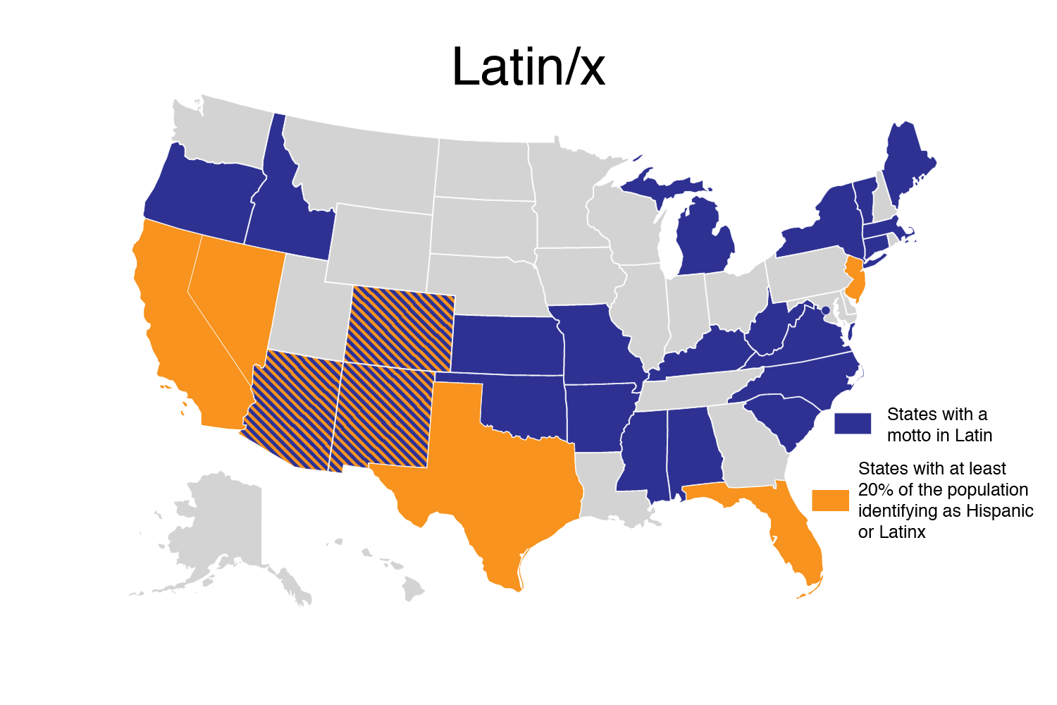
Credit: Evelyn Lamb, based on Theshibboleth Wikimedia (CC BY-SA 3.0); Sources: https://simple.wikipedia.org/wiki/List_of_U.S._state_mottos and https://en.wikipedia.org/wiki/List_of_U.S._states_by_Hispanic_and_Latino_population
States shaded in purple because their state mottos are in Latin: Alabama, Arkansas, Connecticut, Idaho, Kansas, Kentucky, Maine, Massachusetts, Michigan, Mississippi, Missouri, New York, North Carolina, Oklahoma, Oregon, South Carolina, Vermont, West Virginia
States shaded in orange because at least 20% of the population is Hispanic or Latinx: California, Florida, Nevada, New Jersey, Texas
States that are striped to show that both are true: Arizona, Colorado, New Mexico
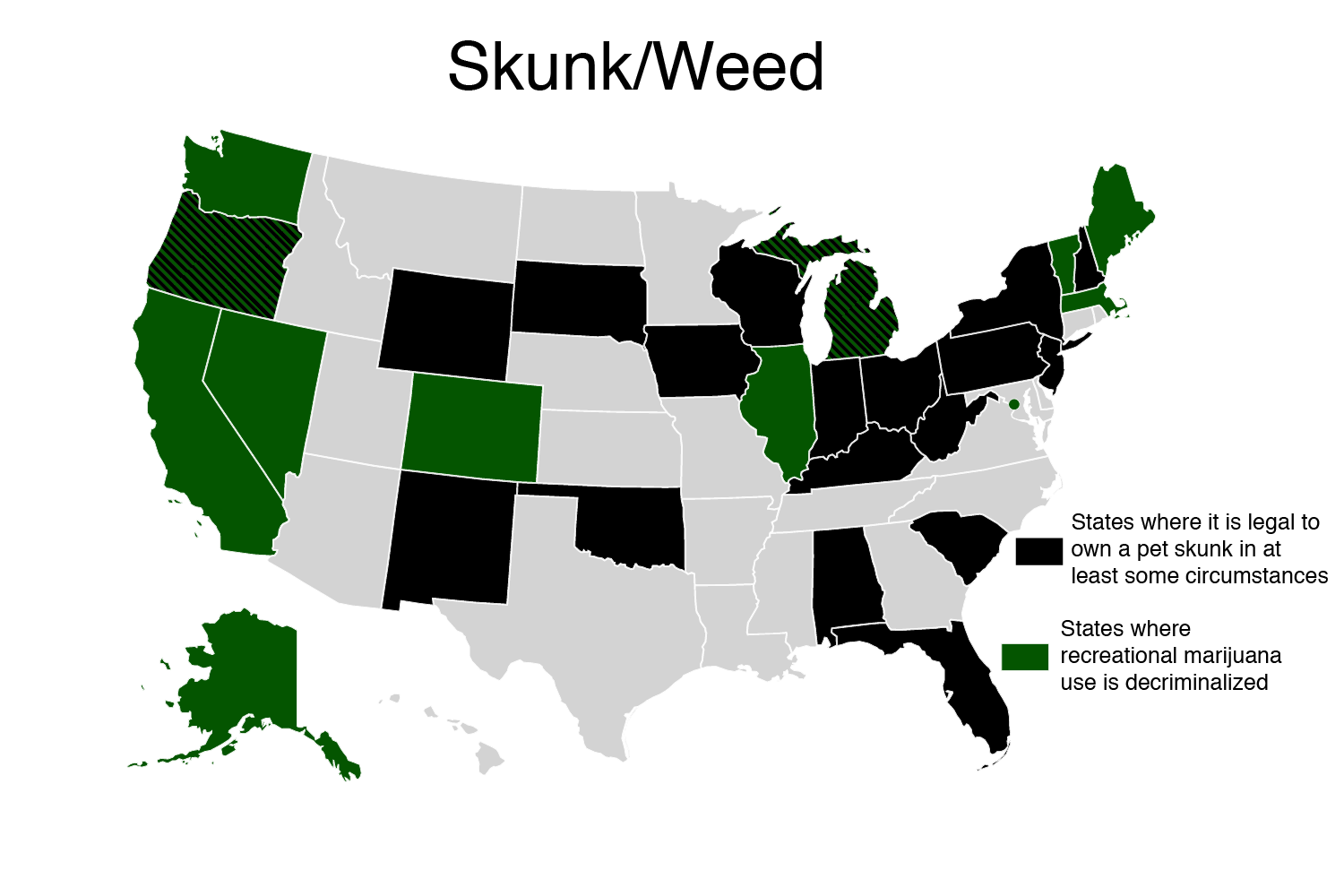
Credit: Evelyn Lamb, based on Theshibboleth Wikimedia (CC BY-SA 3.0); Sources: https://en.wikipedia.org/wiki/Skunks_as_pets#United_States and https://disa.com/map-of-marijuana-legality-by-state
States shaded in black to show that skunk ownership is legal in some circumstances: Alabama, Florida, Indiana, Iowa, Kentucky, New Mexico, Ohio, Oklahoma, South Carolina, South Dakota, West Virginia, Wisconsin, Wyoming
States shaded in green to show that recreational marijuana use is decriminalized: Alaska, California, Colorado, Illinois, Maine, Massachusetts, Nevada, Vermont, Washington, Washington D.C.
States that are striped to show that both are true: Michigan, Oregon
*The legend on the first map is incorrect. Dark green is for states with evergreens as their official trees, and light green is for states with green on their flag. Nevada has both and should be striped.