This article was published in Scientific American’s former blog network and reflects the views of the author, not necessarily those of Scientific American
Destructive flooding hit Venice, Italy on November 12, when the second highest water level on record--1.87 meters (6.2 feet)--inundated over 80% of the historic city at 10:50 pm local time. At least two deaths are being blamed on the flood, and damage will be in the hundreds of millions of dollars, said Venice’s mayor. Venice’s iconic Saint Mark’s Square was inundated by more than one meter of water, while the adjacent Saint Mark’s Basilica was flooded for the only the sixth time in 1200 years. Four of these six floods have occurred in the past twenty years, according to Reuters. A new storm on Friday, November 15, brought the seventh highest water level on record to Venice: 1.54 meters (5.1 feet), and another strong storm on Sunday, November 17, brought the ninth highest water level on record: 1.50 meters (4.9'). Modern record-keeping extends back to 1897 for the city.

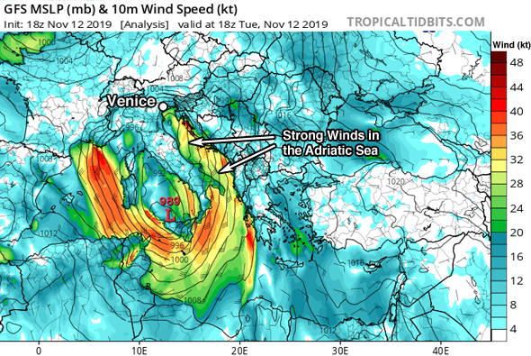
Figure 1. Wind speed in knots at an altitude of 10 meters (color contours; multiply by 1.15 to convert to mph) and mean sea level pressure (MSLP) in millibars (black lines) for 18 UTC November 12, 2019, as analyzed by the GFS model at that time. A strong low-pressure system with a central pressure of 989 mb was located along the southwest coast of Italy. The counter-clockwise flow of air around this low was bringing strong winds in excess of 30 knots (yellow colors) to much of the Adriatic Sea. Venice lies at the north end of the Adriatic, and suffered near-record flooding. Credit: Tropicaltidbits.com
Causes of the acqua alta: wind, rainfall runoff, and full moon tides
On supporting science journalism
If you're enjoying this article, consider supporting our award-winning journalism by subscribing. By purchasing a subscription you are helping to ensure the future of impactful stories about the discoveries and ideas shaping our world today.
The main cause of Venice’s flood was the counter-clockwise flow of air around a strong low-pressure system centered off the southwest coast of Italy. The low brought strong winds in excess of 30 knots (34.5 mph) that blew from south to north, nearly parallel to the axis of the Adriatic Sea. The winds forced a large storm surge into Venice, which lies at the north end of the Adriatic (Figure 1.) The flooding was exacerbated by pre-existing high-water levels in Venice’s lagoon, due to periodic rains that have affected Venice since early November, plus additional heavy rains from the November 12 storm. November 12 was also the date of the full moon, which brought some of the highest tides of the year.
Venice is notorious for these “acqua alta” (high water) events, which periodically flood the renowned St. Mark’s Square—the lowest part of the city—as well as many of the city’s waterfront businesses and sidewalks. As explained by Bob Henson at the Category 6 blog after Venice’s October 2018 acqua alta event, the phenomenon occurs when water is pushed lengthwise from south to north across the Adriatic Sea, parallel to Italy’s east coast. The water naturally sloshes back and forth in the Adriatic over a 22-hour cycle called a seiche. When the seiche happens to slosh into Venice at high tide, it can cause significant flooding during strong storms. Acqua alta events are most common in autumn and winter, when astronomical tides are at their highest.

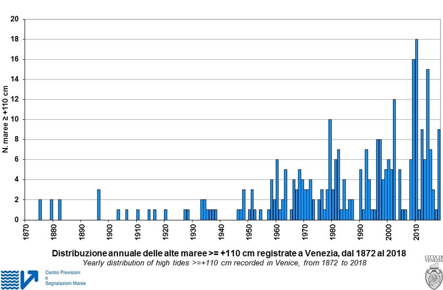
Figure 2. The frequency of tidal flooding in Venice of at least 110 cm (43.3")—enough to inundate over 14% of Venice—has ramped up from about once every three years in the early 20th century to about nine times per year in the 2010s. Image credit: City of Venice
Storm tides in Venice are classified as “exceptional” when they exceed 140 cm (55.1"), which is enough to flood 50% of the city. According to City of Venice records, exceptional storm tides have occurred twenty times since the late 1880s: once in the 79-year period from 1872 to 1950 (April 16, 1936); nine times in the 50-year period from 1951 - 2000; and—ominously—twelve times in just the last two decades, including the past week’s three events. Here are the top-ten highest acqua alta events on record in Venice:
194 cm (76.4”): November 4, 1966
189 cm (74.4”): November 12, 2019
166 cm (65.4”): December 22, 1979
158 cm (62.2”): February 1, 1986
156 cm (61.4”): October 29, 2018
156 cm (61.4”): December 1, 2008
154 cm (60.6"): November 15, 2019
151 cm (59.4”): November 12, 1951
150 cm (59.1”): November 17, 2019
149 cm (58.8”): November 11, 2012

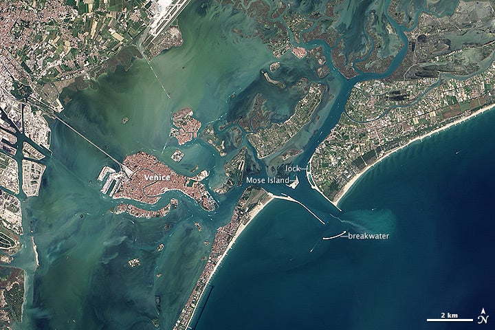
Figure 3. Landsat-8 image of the Venice region on September 4, 2013. Some of the engineering features of the MOSE project are visible. A manmade MOSE island houses buildings and plants that operate the floodgates, which are underwater in arrays on each side of the island. Credit: NASA Earth Observatory
Venice is sinking and sea level is rising
Flooding in Venice is steadily worsening, since sea level is rising at the same time that the city is sinking. Relative sea level has risen about 25 cm (9.8 in) in Venice in the 100 years ending in 2012. About half of the this was due to human-caused global sea level rise, and the other half from subsidence due to natural and human causes. This included compaction of the soil from centuries of building, plus pumping of fresh water from an aquifer beneath the lagoon between the 1920s and early 1970s. The rate of subsidence slowed down by a factor of four after officials put a stop to ground water pumping.
Additional problems: erosion and lack of sand replenishment
Heightened flooding in Venice has also been occurring in recent decades because the protective salt marshes in the lagoon surrounding the city are steadily eroding--largely due to the fact that 600 years ago, the city diverted the courses of the four major rivers that flowed into the lagoon, forcing them to empty into the ocean directly. This was done so that sediments would not build up and allow hostile armies to approach the city via land. Without new sediments to replenish them, the marshes in the lagoon have been steadily eroding away. Water pollution has also contributed to erosion problems by killing eelgrass, the chief anchor of the salt marshes.
Additional problems have been caused by jetties built at the three entrances to Venice's lagoon to hold back the sea. These jetties act as barriers to the natural inflow of fresh sand to replenish beaches in the lagoon, and the sand now accumulates along the jetties. The jetties also act as barriers that disrupt ocean currents and contribute to coastal erosion.
Finally, Venice's lagoon is protected by a number of barrier islands. These islands are steadily eroding, due to construction projects, summer beach crowds, and beach-going vehicles.
A $6.3 billion lagoon defense system is nearing completion
In the wake of the devastating 1966 floods, planning began for a system of inflatable gates that would rise up out of the ocean bed to block incoming storm surges into Venice’s three inlets into the Adriatic Sea. In 2003, construction began on the MOSE Project, which was scheduled to be completed in 2012. However cost overruns have tripled the price of MOSE to at least $6.3 billion, and the project has been beset by prolonged delays and corruption--culminating in the arrest and indictment of the mayor of Venice. MOSE is now expected to debut in 2022 at the earliest. “If Mose had been working, then we would have avoided this exceptional high tide,” city mayor Luigi Brugnaro Brugnaro said in a Reuters interview.
In theory, the gates and additional coastal defense measures being undertaken will protect Venice against storm surges bringing storm tides of up to 3 meters (9.8’). Lower parts of the city begin flooding at a water level of 0.8 m, and the gates are designed to be closed when water levels exceed 1.1 m (3.6’)—enough to flood 14% of the city. However, multiple studies have found that if sea level rises 0.5 m (1.6’), the gates would allow considerable flooding of Venice, since water would find new entry points into the Venice lagoon to the north and south, and leak through the gates. Furthermore, the gates do nothing to reduce the incidence of nuisance flooding--when ordinary high tides combined with heavy rains flood less than 12% of the city. With some climate scientists warning that Earth could see sea level rise 0.5 m by 2050 – 2080, the MOSE gates may have to close every day and open only at the time of low tide just a few decades after they go into service. Operation of the gates in this manner would trap pollutants in the lagoon and adversely affect the ecosystem--and greatly restrict boat traffic through the gate locks. Considering that it has already taken more than 50 years from the initial planning stages to get the current MOSE system nearly ready, Venice needs to start planning now for how it will manage sea level rise when MOSE is obsolete 50 or so years from now.
They’d best learn from their mistakes. In a 2017 investigative report, “Venice and MOSE: story of a failure,” the Italian newspaper La Stampa found that the 36-ton hinges that connect the gates to their concrete housing were in an advanced state of corrosion after spending years underwater, and were at an extremely high risk of being unusable. Yale's Environment 360 website has an excellent feature on the MOSE project by Jeff Goodell—author of the must-read 2017 book, The Water Will Come: Rising Seas, Sinking Cities, and the Remaking of the Civilized World. I reviewed the book in 2017.
Andrew Freedman of the Capital Weather Gang has an excellent photo essay of this week’s flooding in Venice.