This article was published in Scientific American’s former blog network and reflects the views of the author, not necessarily those of Scientific American
I know, I know, it's been too long! Sorry, my darlings, I had a sudden influx of good weather to deal with here in Seattle. When it's sunny in late-September/early-October, you take advantage, because it could be your last chance at the warm and sunny for months. I did stuff in the sunshine! I visited Mount St. Helens, even! I got some outstanding photographs of some really nifty volcanic features, so I'll be sharing those with you shortly.
In the meantime, we return to In the Path of Destruction! In our previous installments, we saw Mount St. Helens wake up and suffer some pretty extreme swelling, and we ended on the eve of eruption. Now it's 0 hour. Ready or not, thar she blows.
18 May 1980
On supporting science journalism
If you're enjoying this article, consider supporting our award-winning journalism by subscribing. By purchasing a subscription you are helping to ensure the future of impactful stories about the discoveries and ideas shaping our world today.
USGS Geologist Richard Waitt: "The north brow bulged a phenomenal five feet a day."
I like that. "Brow" works better than "flank," considering how high up that bulge was.
***
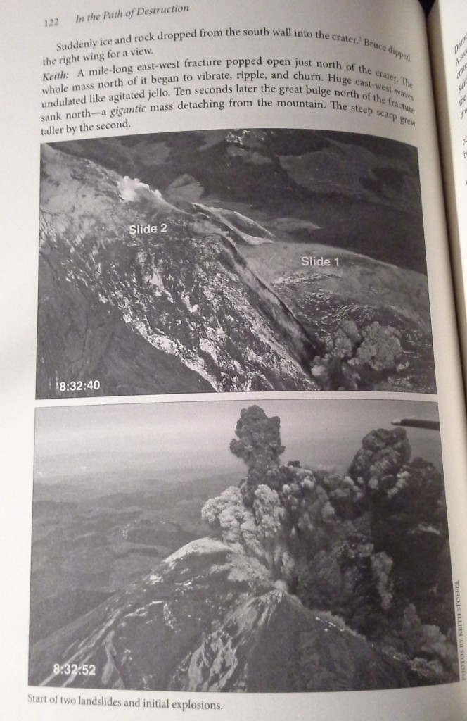
Waitt summarizes the events beginning at 8:32:11 am. Earthquake, slides, lateral blast, third landslide, larger blast surge. It takes only six minutes for "234 square miles - ten Manhattans" to become a moonscape.
Six minutes. Ten Manhattans. And folks - that wasn’t even the biggest eruption St. Helens is capable of. It was just a VEI 5 - way under Krakatoa, which was a robust VEI 6. All that mayhem, yet she's capable of so much more.
(Not that she’s likely to do that again in our lifetimes. She'll probably do no more than dome build for awhile. She's still dangerous, but not exceptionally so. Still: this is why you've gotta have a very healthy respect for your young stratovolcanoes.)
***
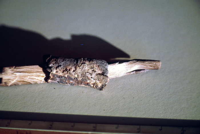
So, if you were standing on Mounts Rainier or Adams, you would've gotten showered by ash and charred bits of tree. The eruption was so powerful that pieces of Mount St. Helens’s forest ended up fifty miles away. We're talking chunks, not wee fragments, people. The photo I'm attaching is a hunk that landed on Mount Adams - 33 miles east.
***
Chapter 7: Air
Okay, now we're on to the meat of the book: the witness statements. Waitt has left them in their own words, from their first-person point of view. This is gonna be awesome.
I love the beginning quote: "Here's ANOTHER a**hole telling us the mountain has erupted." - Air-traffic controller.
***
So, this is why you should buy this book: gripping survivor stories and great photos you won't see elsewhere. These two were taken right over Mount St. Helens as the cataclysmic eruption began. There's much more where this tiny sample comes from.
If you use this link to purchase, you'll support my blogging. Thanks!
***
The bulging face of Mount St. Helens falls away beneath their airplane. The eruption cloud boils out and grows beneath and just behind Judson and the Stoffels.
Keith Stoffel: RUN AWAY!!!
Bruce Judson: *redlines the plane*
Dorothy Stoffel: "S**T! GO FASTER!... S**T!"
Bruce: *speeds up to Mach Nearly Rip the Wings Off*
And that, children, is what we call a high butt-pucker factor.
Dorothy's words are a direct quote, by the way (aside from my asterisks to make this relatively work-and-school safe) At least we can be sure her hubby got her a birthday present she'll not soon forget.
***
Bruce Judson to Air-Traffic Control (Seattle Center): Whole north side fell down, mountain go boom!
Seattle Center: Which part?
Bruce: ALL THE PARTS!
Seattle Center: *sighs, rolls eyes* No, I mean, how big is the eruption?
Bruce: *screams* "F***ing big!"
Yup.
(Thanks to some first-class maneuvers from Bruce, he and the Stoffels all escaped, and landed safely in Portland just after 9am. They were the only people 0 kilometers from the volcano to survive.)
***
Northwest Airlines Flight 78 left Seatac Airport (SEA) near Seattle at 8:23am. Curious about what Mount St. Helens was up to, they diverted to fly near it. They had just flown near Highway 12 east of Randle, WA.
Flight crew and passengers: Hey, Mount St. Helens, whatcha doin?
Mount St. Helens: Oh, you know. Eruptin'.
Everybody: Daaang!
Flight crew: Whelp, that was close enough. *vroom*
United pilot over radio: That's not an eruption, sillies! It's a thunderstorm!"
Flight 78 Co-pilot: Pfft, right. A thunderstorm west of the Cascades first thing in the morning. Whatevar.
***
United Pilot William L Airis watches MSH vanish beneath a huge eruption cloud.
Air-Traffic Control: "You see anything unusual?"
Airis: "Yeah. The mountain just disappeared."
***
United Pilot Peter Gallant takes off from SEA at 8:40am and sees a huge lightning-streaked cloud to the south.
Gallant: Yeah, that's a big storm over there.
Tower guy: *screaming* "Mount St. Helens just blew up!"
Gallant: Ooo, neato. *makes 90 degree turns so all his passengers get to see*
***
Interesting. Oregon State University associate professor Chuck Rosenfeld was doing overflights measuring hotspots on Mount St. Helens. He'd noticed they were getting hotter May 16th and 17th. A predawn flight at just before 6am on the 18th "showed a huge thermal output from the bulge and some new spots below Goat Rocks."
He went to take a photograph later that morning. His plane took off around 8:40 - just before he got word the volcano was erupting. He and his pilot flew all over around the mountain and up the Toutle River valley all the way to Elk Rock, inspecting the landslide and ash columns and watching mudflows. Amazing.
***
Columbia Helicopters pilot Dwight Reber tried to get in to rescue Reid Blackburn and Harry Truman. He couldn't even get close. The ash cloud was too thick.

That's it for this edition. Next time, we get a climber's-eye view of the eruption as people report from nearby Cascade volcanoes.