This article was published in Scientific American’s former blog network and reflects the views of the author, not necessarily those of Scientific American
As 2017 ends and 2018 begins, we shall have a blast from the past while returning to one of our favorite subjects: Mount St. Helens! I spent an appreciable part of last year going through the USGS photo archives and picking out some of the best eruption photographs for you. It's been a while since we delved into that collection and sampled its delights. Let us resolve to set our worries and woes aside, resolve to deal with our resolutions later, and sit ourselves down with some volcanic goodness.
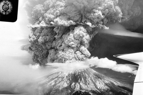
Plinian eruption column rising from the central crater of Mount St. Helens. Aerial view looking northeast showing cauliflower-like structure of eruptive column and a pall of dust rising from area north of amphitheater-shaped crater. Photo by J.G. Rosenbaum. Skamania County, Washington. May 18, 1980, 1330 PDT. Portion of Figure 12, U.S. Geological Survey Professional paper 1250. Credit: USGS
Absolutely magnificent shot of the Plinian column at 1:30pm PDT on May 18, 1980. Look at the textures in that ash column!
On supporting science journalism
If you're enjoying this article, consider supporting our award-winning journalism by subscribing. By purchasing a subscription you are helping to ensure the future of impactful stories about the discoveries and ideas shaping our world today.
If you want to read the story of the eruption from the very first inklings that Mount St. Helens was going to do something spectacular through what the cataclysmic eruption did to that lovely Pacific Northwest forest, start here and carry on.
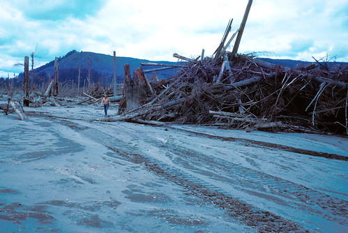
Trees at distal margin of Mount St. Helens debris flow.D.R. Crandell for scale. Cowlitz County, Washington. July 11, 1980. Credit: USGS
We'll begin with one of my favorite photos of the lot. Not only is it an excellent view of the enormous jumbles of broken trees dumped at the edge of the debris avalanche, but that geologist who's walking amongst all that destruction like an action science hero? That's Dwight "Rocky" Crandell. He is a personal hero of mine. He was one of the two geologists who thoroughly researched Mount St. Helens's eruptive history and warned everyone that she was hella dangerous just a couple years before she blew up. He was one of the main reasons more people didn't die. He was an incredible person who did an incredible job, and never gave himself enough credit for it.
Please raise a glass to one of the best.
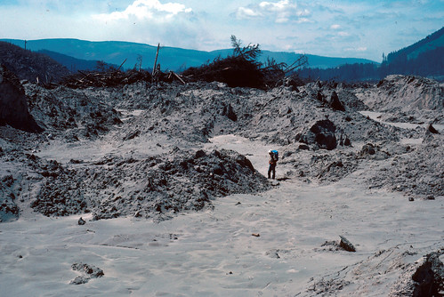
Near distal margin of Mount St. Helens debris flow about 3 miles east of Camp Baker.D.R. Mullineaux for scale. Cowlitz County, Washington. July 15, 1980. Credit: USGS
Okay, we've seen Dwight "Rocky" Crandell. Now let's have the other author of the paper that warned us Mount St. Helens was still terribly dangerous, just two years before she erupted. This is Donal Mullineaux, investigating the tail end of the debris avalanche deposit. This thing traveled over twelve miles down the North Fork Toutle River valley. You can see how tall the hummocks are even here, three miles downstream from Camp Baker, almost at the end of the flow. And look at that tangle of trees plowed up in the background!
We tend to think of volcanic eruptions as ash clouds rising into the air or lava flowing down slopes, but eruptions like this one introduce us to processes that don't usually make it into those television specials on volcanoes. This is one of the largest volcanic debris avalanches human beings have ever witnessed. And this photograph captures some of the dramatic power and mind-boggling destruction of that event.

Credit: USGS
View of lahar from May 18, 1980, down the Muddy River drainage, southeast flank of Mount St. Helens. A beheaded Shoestring Glacier is visible on the mountain. Photo by Lyn Topinka. Skamania County, Washington. October 1980.
Here's a view looking up the Muddy River drainage towards Mount St. Helens. There's a lot going on here. We see the massive lahar, of course. If you look upstream a bit, you'll see little kapukas. I can't tell from this photo if those trees are dead or just covered in ash, but they clearly weren't bulldozed and buried like the rest of the trees in the lahar's path. Although most of her eruptive fury was expended to the north, the south side of the volcano sustained quite a lot of damage, too - it's covered in ash and other deposits. That huge gash you see is the valley carved by Shoestring Glacier, which has had its head lopped off: note the huge notch in the summit there. It's a beautiful clear day, one of the finest October has to offer in the Pacific Northwest, and so the bit of steam drifting from within the crater and wafted east by the prevailing winds is visible against the lovely blue sky. It's a magnificent photo, so it shouldn't surprise you a bit to learn Lyn Topinka took it.
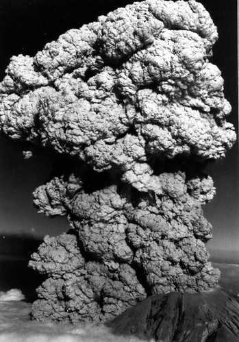
Oblique aerial view of Mount St. Helens as viewed from the northwest, showing the second eruptive pulse at about 1826:30 PDT on July 22, 1980, about 13 seconds after the view shown in figure 5 (photo no. 13). Note that a vertical column is forming rapidly. Highest point on the eruption cloud is about 4,100 m above the highest point on the rim of the amphitheater. Photo by J.W. Vallance Skamania County, Washington. Figure 6 in U.S. Geological Survey. Professional paper 1335. 1986. Credit: USGS
This may look very much like an image from May 18th, but it was actually taken two months later on July 22. You might think that she'd expended everything in her in her nine hours of ferocity in May, but she had plenty left. She hurled impressive columns of ash skyward five more times between then and mid-October.
Of course, that deep notch blasted out of the north face couldn't hold back the columns, and pyroclastic flows would go dramatically spilling out and tumbling down to the valley below. This July eruption is a completely spectacular example of that sort of thing. Just look at the development on that baby. Fierce!
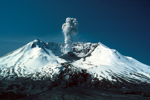
Ash burst from Mount St. Helens as seen from Harrys Ridge. Snow covers upper part of volcano Skamania County, Washington. May 19, 1982. Photograph by Lyn Topinka. Credit: USGS
Nearly two years to the day after the May 18, 1980 eruption, Mount St. Helens donned a snazzy jacket of snow and put on a show, emitting a column of steam and ash from her crater dome. Lyn Topinka framed the shot perfectly. Doesn't she look dashing? I swear she looks like the volcanic version of James Bond right here.
Happy New Year to you, my darlings! Here's hoping 2018 will be positively volcanic in the best possible ways.