This article was published in Scientific American’s former blog network and reflects the views of the author, not necessarily those of Scientific American
My honorary nephew came to visit from far away, and since my mission in his life has been to feed his love of geology, we arranged a nice family day trip up to Mount Rainier. Since many of you will probably eventually make a trip out to see the continental US's mightiest volcano, and most of the rest of you would at least like to live it vicariously, I figured I'd share our itinerary with you.
Before you go: make sure you've done all the necessary car maintenance like checking tires, topping up fluids, and such. Have an emergency kit with you. Be prepared for any weather: Mount Rainier is a tall beast that creates its own weather, and that sunshine on the valley floor can turn to snow up top, even in summer!
Rule #1 for a great trip once all that's sorted: be sure you have a good camera! Bring spare memory and batteries because you will definitely need them. (Unless you have a monster like my new Lumix, which apparently thinks one battery is quite adequate, thank you.)
On supporting science journalism
If you're enjoying this article, consider supporting our award-winning journalism by subscribing. By purchasing a subscription you are helping to ensure the future of impactful stories about the discoveries and ideas shaping our world today.
Rule #2: Consult a geologic guidebook, like Pat Pringle's excellent Roadside Geology of Mount Rainier National Park and Vicinity.
We'll begin from Enumclaw from around noon-ish, because you should be able to get there easily from any point in Seattle by then, even if you're like me and refuse to start traveling before rush hour has died down. You can take some time to eat and pick up any last-minute necessities there. Make sure you bring plenty of snacks and drinks: it's hard to find inexpensive places to munch on the mountain! Depart with a full gas tank and a heart ready for jaw-dropping vistas.
Optional Stop 1: Mud Mountain Dam
This is a great place to come if you have kids and some time, and especially great if it's a hot day. There are picnic tables available if you want to lunch there. Bring a swim suit and a towel if you want to enjoy the splash park!
The viewing platform is a fantastic place to get a look at the deposits the White River cuts through. Not everything is volcanic! As you're looking upstream towards Mount Rainier, turn to the left bank. You'll see some bare areas in the cliff, where light tan deposits are exposed. You'll need binoculars or a camera with a good optical zoom to see the details.

Glacial and volcanic deposits exposed by a landslide along the White River. Credit: Dana Hunter
From the bottom up, you're looking at Vashon pro-glacial outwash from an advancing Ice-Age ice sheet, Vashon till dropped by the over-riding glacier, and mudflow deposits from the Osceola mudflow. Yes, all the way up there. That is indeed how deeply the river Valley was filled. Terrifying, isn't it?
The river has since cut a channel through those deposits, so remember that sediment in the channel is younger than the stuff in the cliff. The fan-shaped slope to the left, covered in young trees, is a landslide deposit from 1996. To the right, the terrace arrowing its way into the river bend is another lahar deposit thousands of years younger than the Osceola mudflow. A lot of lahars have flowed down the White River's channel.
You can find out more about the dam here.
Optional Stop 2: Pull Out Along the White River
You'll be traveling along the White River for quite a ways. Several pullouts allow you access to the river, which are great when the flow is low enough to view it safely. You'll get to see huge boulders brought down by lahars like the Osceola Mudflow, the glacial rock flour that gives the White River its color and its name, and fine examples of a braided stream. Plus, the natural beauty does a heart good.
The Road to Sunrise
Nearly everyone goes to Paradise. You, also, will go to Paradise, but today is not that day (at least, not for any length of time). Today, we're going to the Sunrise Visitor Center.
On the road up, keep your eyes peeled for platy and columnar andesite. There are some really marvelous exposures here, with pullouts if you want to stop. The safest one if you have kids is just past the massive wall of andesite - look for a pullout on your right. On the left side of the road, stately gray andesite columns of the Burroughs Mountain lava flow jut horizontally from the embankment. There's a sign explaining how the columns formed there.
This is the perfect drive for seeing how lava flows react when they are traveling down a slope or encountering a cold surface like a glacier. Can your passengers figure out why some of the columns are vertical and some are horizontal?
At the top of the road, there's a pull-out with plenty of parking. The views from up here are truly magnificent. The North Cascades and Tatoosh Range, carved into sharp peaks by thousands of years of glaciation, rear up in the distance. On clear days, you'll get marvelous views of Mount Adams to the east. And if you cross the street to the Palisades Lakes trailhead, you'll get a lovely view of perfect mountain tarns. If you're one of those families that likes to start early and hike often, the trail to Sunrise Lake is utterly lovely - and you might see a pika!
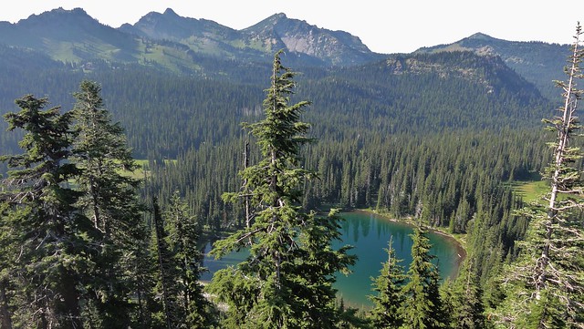
Sunrise Lake from the Palisade Lakes trailhead. Credit: Dana Hunter
Driving on, you'll get some incredible views of Rainier's summit, and gorgeous alpine meadows. There are plenty of places to stop on both sides of the road to take photos. Little Tahoma, the pointy peak, is composed of eroded lava flows. It, along with Rainier's great height, makes this volcano one of the most distinct landmarks in the world.
You might notice that the volcano looks a bit concave here. This face is where the Osceola mudflow originated. Four cubic kilometers (1 m³) of summit, water, ice, and snow mixed in a thick slurry that would have been deadly to anyone living near the White River valley. The mud flowed all the way to Tacoma and reached Puget Sound. That, my friends, is an incredible distance. And the distinct possibility of it happening again is why downstream communities like Orting have lahar alarms the way midwestern towns have tornado sirens.
But for the moment, we're just going to stand here and admire the peaceful meadows with the currently serene giant towering in the distance, and appreciate the fact that untold destruction can give rise to remarkable beauty.
On the next leg of our trip, we visit the ghosts of glaciers past, view the living one that gives birth to the river we just traveled along, and then go dabble our fingers in waters that show us a hint of the hydrothermal heart of the mountain.