This article was published in Scientific American’s former blog network and reflects the views of the author, not necessarily those of Scientific American
I've been slowly going through the extensive USGS collection of Mount St. Helens eruption photos, downloading each and every one and bringing you the best of what I find. I put that project on the back burner with other projects and the election heating up. But the election is over, and with the way Trump and his team are handling the government's internet presence, I'm not entirely certain we'll have a USGS database to spelunk for much longer. So I'm trying to get this done.
Here are some of the many delights I've found. There will be many, many more to come.
On supporting science journalism
If you're enjoying this article, consider supporting our award-winning journalism by subscribing. By purchasing a subscription you are helping to ensure the future of impactful stories about the discoveries and ideas shaping our world today.
Absolutely marvelous photo of a phreatic explosion in the pumice deposits from the May 18th eruption. This photo is from May 23rd - things were still hot enough to melt ice and snow and heat them into steam, which would then blow out craters in the volcanic debris covering the North Fork Toutle River valley. These aren't technically eruptions, although they are a part of the overall volcanic activity.
-
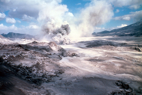
"View to east of upper North Fork Toutle drainage with phreatic explosion in pumice flows of May 18 eruption of Mount St. Helens. Skamania County, Washington. May 23, 1980." Credit: USGS
Lovely patterns in this pyroclastic flow from June 12, 1980. It's like Mount St. Helens was painting designs on a canvas she'd made.
-
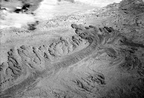
"Aerial view of pyroclastic-flow deposits of June 12, 1980, eruption of Mount St. Helens, showing a tongue, nearly 1 km long, and its lobes. The deposits overlie an older thin tongue of June 12 deposits. Pyroclastic-flow deposits (light gray) and debris-avalanche deposits (dark gray) of May 19 can be seen at upper left. View looking northwest from southeast side of pumice plain. Photo by P. Rowley. Skamania County, Washington. July 13, 1980. Portion of Figure 290, U.S. Geological Survey Professional paper 1250." Credit: USGS
I've hit a streak of black and white photos, and I'm trying to mix it up, but this one's just too striking to pass up. This is what a mountain looks like after it's spilled its guts all over the landscape.
-
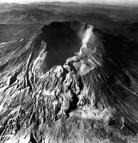
"Aerial view of Mount St. Helens looking south, after the May 18 eruption. Remaining lower part of Forsyth Glacier in left center. Loowit Glacier is completely gone. Many pyroclastic-flow deposit lobes can be seen in foreground. Windblown dust obscured some surface details. Photo by R.M. Krimmel. Skamania County, Washington. September 9, 1980. Figure 32, U.S. Geological Survey Professional paper 1250." Credit: USGS
OMIGOSH, everybody, look at this delicious erosion happening in the volcanic deposits along what is probably Smith Creek. I am in love with these lacy little waterfalls carving scallops in all that lovely debris.
(Now, before creationists go getting all giddy over it, rapid erosion in unconsolidated debris is a heck of a lot different than erosion of solid rock. You can't use this to back up your asinine ideas about the Grand Canyon being rapidly carved. Sorry not sorry.)
-
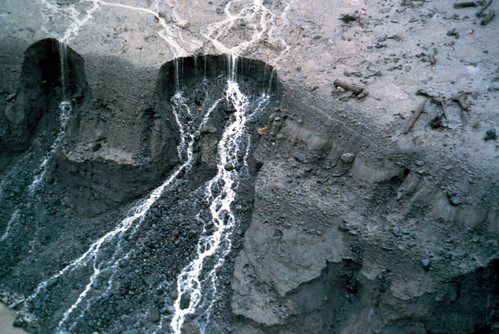
"Erosion along bank of Smith Creek(?) during first heavy rains after the May 18, 1980, eruption of Mount St. Helens. Photo by Holly A. Martinson. Skamania County, Washington. November 6, 1980." Credit: USGS
October 1980 lava dome. Note the wee little helicopter parked on the crater floor. Mount St. Helens spent years building domes and them blowing them to smithereens before she finally settled down and left one standing.
-
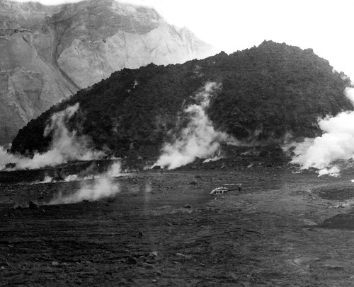
"Low aerial view of lava dome that developed in the crater of Mount St. Helens since the October 1980 eruption. The dome is approximately 300 feet high and 800 feet across. The helicopter in foreground shows scale. Photo by Terry Leighley. Skamania County, Washington. January 7, 1981. Published on p. 98, lower photo, in U.S. Geological Survey. Earthquake information bulletin, v. 13,no.3. May-June 1981." Credit: USGS
St. Helens Bridge and the Terrible, Horrible, No Good, Very Bad Day. Human for scale.
-
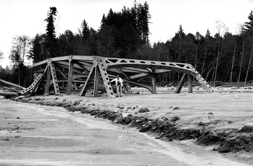
"The 75-m (247-ft) St. Helens bridge on State Highway 504 after May 18 eruption of Mount St. Helens when it was washed out by the mudflow on the North Fork Toutle River. This steel structure was carried about half km (quarter mile) downstream and was partially buried by the mudflow. Man for scale by bridge girder. Photo by R.L. Schuster. Cowlitz County, Washington. 1980. Figure 406-B, U.S. Geological Survey Professional paper 1250." Credit: USGS