This article was published in Scientific American’s former blog network and reflects the views of the author, not necessarily those of Scientific American
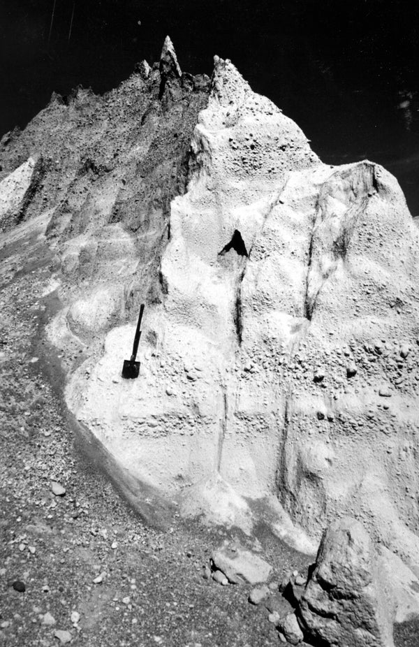
I love this really stark photo of pyroclastic flow deposits. If it wasn't for the shovel, it would look like something from a 1950s sci fi set.

Flow units of pyroclastic-flow deposits of May 18 eruption of Mount St. Helens in northern wall of the big phreatic-explosion pit. Shovel for scale. Photo by P. Rowley. Skamania County, Washington. 1980. Portion of Figure 297, U.S. Geological Survey Professional paper 1250. Image and caption courtesy USGS.
This is the bank of the Columbia River right by Vantage, WA. Note the generous dusting of ash from the May 18th eruption. That haze you see over the river is more ash making its way east with the prevailing winds.
On supporting science journalism
If you're enjoying this article, consider supporting our award-winning journalism by subscribing. By purchasing a subscription you are helping to ensure the future of impactful stories about the discoveries and ideas shaping our world today.
The ash is pretty much gone now, washed off the rocks and mixed in with the soil. This eruption was huge for us, but pretty middling as far as the geologic record is concerned. Mount St. Helens has experienced much bigger bangs in the past, leaving extensive ash deposits that dwarf what the cataclysmic May 18th eruption managed. The second photo shows some of those ash layers and a map of their distribution. More information about the volcano's history can be found here.
Nifty, eh?

Ashfall area of May 18 eruption of Mount St. Helens on Columbia River at Vantage, Washington, showing bridge where Interstate 90 crosses Columbia River and ash cloud being blown from the west bank to the east bank of the river. Kittitas and Grant Counties, Washington. July 17, 1980. Image and caption courtesy USGS.
After the May 18 eruption, pretty much everything around Mount St. Helens looked like a post-apocalyptic nightmare. There was no life. A lot of people thought there never would be, it looked so extreme.
But volcanoes experience continual cycles of creation and destruction. What happened to Mount St. Helens was nothing it hadn't endured before and will survive again. Living things saw a bunch of empty real estate and wasted no time moving in. These avalanche lilies grew up within the devastated area early that June, less than a month after the cataclysm. They settled in the blast deposits just ten miles northwest of the volcano. Annihilation was swiftly followed by renewal. Life on this planet is remarkable for its ability to persevere no matter what conditions it faces.
These delicate flowers growing on a barren blast field tell us that life will always find a way to endure.*
*Well, up until the sun consumes Earth, anyway, but that event billions of years in the future need not disturb us now.

Life returns to the vicinity of Mount St. Helens. B, Avalanche lilies (Erythronium montanum) growing through blast deposits from May 18 eruption, about 10 miles northwest of the volcano. Skamania County, Washington. June 8, 1980. Page B109, U.S. Geological Survey Professional paper 1240-B and Figure 57, U.S. Geological Survey Professional paper 1249. Image and caption courtesy USGS.
Alas, my time is short, and that's all for now. I'll have more for you soon!