This article was published in Scientific American’s former blog network and reflects the views of the author, not necessarily those of Scientific American
On supporting science journalism
If you're enjoying this article, consider supporting our award-winning journalism by subscribing. By purchasing a subscription you are helping to ensure the future of impactful stories about the discoveries and ideas shaping our world today.
A long, long time ago in a city far, far away, I learned something rather astonishing about the city of New Orleans. I mean, it's probably not astonishing to most people, but to a girl who grew up at a minimum elevation of 7,500 feet, finding out that a good half of a major American city hangs out below freaking sea level was jarring as heck. I had no idea how things had gotten that way, or why we'd want to build in such a place.
I wish teenage me had been able to read "How Humans Sunk New Orleans," which does an absolutely marvelous job explaining how a town that started above the sea eventually became a booming city that sunk below it.
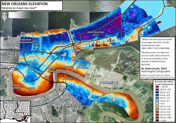
Understanding how these features rose, and why they later sank, entails going back to the end of the Ice Age, when melting glaciers sent sediment-laden runoff down the Mississippi to the Gulf of Mexico. Starting around 7,200 years ago, the river’s mouth began pressing seaward, dumping sediments faster than currents and tides could sweep them away. The mud accumulated, and lower Louisiana gradually emerged from the Gulf shore. Areas closest to the river and its branches rose the highest in elevation, because they got the most doses of the coarsest sediment. Areas farther from the river got just enough silt and clay particles to rise only slightly above the sea, becoming swamps. Areas farthest out received scanty deposition of the finest particles amid brackish tides, becoming grassy wetlands or saline marsh. The entire delta, under natural conditions, lay above sea level, ranging from a few inches along the coastal fringe to over a dozen feet high at the crest of the Mississippi River’s natural levee. Nature built lower Louisiana above sea level, albeit barely—and mutably. The story spans thousands of years and thousands of enterprising humans, determined to make nature bend to their will. Eventually, they figured out how a combination of devices like walls, levees, pumps, and canals could dry out the land and give them more room to build. And they discovered that nature is not so easily controlled. We're an ingenious species, but we can't see all of the consequences of our innovations. Even when we do see, sometimes we have little choice. We built a major American city in a horribly fragile area, and now we find ourselves unable to abandon it. We grabbed the Mississippi by the delta, and now we're not sure if it's going to hurt more to hold on or let go. It's not just New Orleans: it's the entire delta we've remade. I had little grasp on that feat until I read John McPhee's essay on it a few years ago. Listen to what the river was, and what it built, before we came to restrain it: The Mississippi River, with its sand and silt, has created most of Louisiana, and it could not have done so by remaining in one channel. If it had, southern Louisiana would be a long narrow peninsula reaching into the Gulf of Mexico. Southern Louisiana exists in its present form because the Mississippi River has jumped here and there within an arc about two hundred miles wide, like a pianist playing with one hand—frequently and radically changing course, surging over the left or the right bank to go off in utterly new directions. Always it is the river’s purpose to get to the Gulf by the shortest and steepest gradient. As the mouth advances southward and the river lengthens, the gradient declines, the current slows, and sediment builds up the bed. Eventually, it builds up so much that the river spills to one side. Major shifts of that nature have tended to occur roughly once a millennium. The Mississippi’s main channel of three thousand years ago is now the quiet water of Bayou Teche, which mimics the shape of the Mississippi. Along Bayou Teche, on the high ground of ancient natural levees, are Jeanerette, Breaux Bridge, Broussard, Olivier—arcuate strings of Cajun towns. Eight hundred years before the birth of Christ, the channel was captured from the east. It shifted abruptly and flowed in that direction for about a thousand years. In the second century a.d., it was captured again, and taken south, by the now unprepossessing Bayou Lafourche, which, by the year 1000, was losing its hegemony to the river’s present course, through the region that would be known as Plaquemines. By the nineteen-fifties, the Mississippi River had advanced so far past New Orleans and out into the Gulf that it was about to shift again, and its offspring Atchafalaya was ready to receive it. By the route of the Atchafalaya, the distance across the delta plain was a hundred and forty-five miles—well under half the length of the route of the master stream. For the Mississippi to make such a change was completely natural, but in the interval since the last shift Europeans had settled beside the river, a nation had developed, and the nation could not afford nature. The engineering feats it took to bring that river to heel, and keep it there, were mind-boggling. These two essays together will help you see New Orleans in a way you may never have considered. Even if you already know the story, these are two brilliantly-written pieces that will reward every minute you spend with them. The feats that built New Orleans were impressive, but it's time to change perspective. We can't wrestle nature and win forever. To survive the coming centuries, we'll need to find ways to accommodate those forces. We'll have to rethink our relationship entirely.