This article was published in Scientific American’s former blog network and reflects the views of the author, not necessarily those of Scientific American
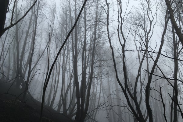
SANTA ROSA, CA. Propelled by gale-force Diablo winds, the devastating wildfire struck the Pepperwood Preserve—a biodiverse “hotspot” that is home to 900 species of plants and animals—during the night of October 8. It swept through low-lying chaparral, scorched grasslands, and incinerated dead or damaged trees that had fallen in the forest, leaving behind ghostly white ash imprints of their canopies against the burnt ground. Some stately Douglas firs became stark black skeletons, while the hearty, and abundant, native oaks fared better, their dull green leaves turned brittle and brownish gold.
The uncontrolled blaze, estimated to have burned more than 85 percent of Pepperwood’s 3,200 acres to varying degrees, was part of the Tubbs fire, the worst of multiple wildfires last month in northern California’s wine country. Together they claimed at least 43 lives and destroyed some 8,400 homes and buildings around Sonoma and Napa Counties. But out of the ashes comes an important opportunity to learn from nature as researchers study the fire’s impact on the land, water, vegetation and wildlife of the Pepperwood Preserve. The findings could help inform decisions made by land managers and urban planners in the wake of the deadliest and most destructive fires in California history.
“There is a huge scientific opportunity to see what happens here after the fire,” says Lisa Micheli, an energetic freshwater hydrologist who is the president and CEO of the Pepperwood Foundation. It was established in 2005 to manage the preserve for ecological and land management research, conservation and community involvement. Working with a close-knit team of inside and outside experts, she is leading a rapid-fire effort to do everything possible to learn from the fire’s footprint using high-tech ground and remote sensing equipment, as well as good old-fashioned field work.
On supporting science journalism
If you're enjoying this article, consider supporting our award-winning journalism by subscribing. By purchasing a subscription you are helping to ensure the future of impactful stories about the discoveries and ideas shaping our world today.
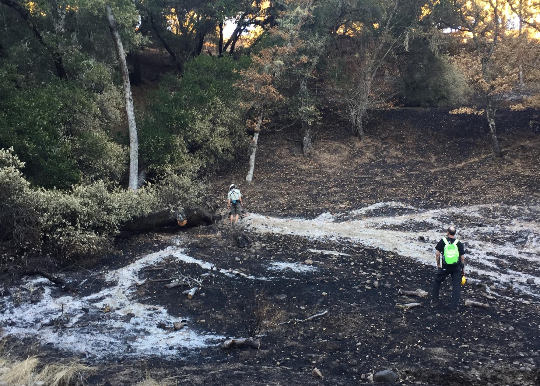
Credit: Lisa Micheli
To be clear, everyone here is absolutely devastated by what David D. Ackerly, a plant ecologist whose field research is centered at Pepperwood, called the “deeply visceral tragedy” of human and property fire losses. Indeed, despite the horrific television and print images already in my mind, I was not prepared for the jarring, tear-inducing glimpses of brick fireplaces amidst burned out home ruins and eerie car and truck frames below the twisting, oak-lined Franz Valley Road on the way to the preserve. I tagged along on a scheduled visit of hydrologists evaluating erosion problems at Pepperwood, among the first groups to traverse the burnt landscape here. We met near the twisted metal debris of an old storage barn destroyed by the fire, now cordoned off with yellow hazard tape.
Fire has long been a regular visitor to this rugged eastern Sonoma terrain in the Mayacamas Mountains at the southern end of California’s North Coast Range. The Wappo Native Americans are said to have burned local vegetation to improve production of acorns and other seeds for food, said Micheli. More recently, however, the encroachment of housing development northward from the crowded San Francisco Bay Area—and years of damaging drought and warmer temperatures—have led to an uneasy land management truce in northern California involving fire suppression in areas near human habitation. Roughly a 90-minute drive north from San Francisco, the Pepperwood Preserve is about 25 minutes northeast of downtown Santa Rosa, the Sonoma County city that suffered devastating loss of life and property in the Tubbs fire.
“The deep dilemma of wildfire in the West is we know that ecosystems are adapted to fire and may flourish. Fire is part of the landscape and yet devastating when it hits a community,” said Ackerly, a leading climate expert at the University of California, Berkeley. “What does it mean to co-exist with fire? We’re never going to stop fires from burning. It’s a question of better urban planning, building codes, and forest management.”
Indeed, studying the post-fire ecology at Pepperwood could enhance understanding of the complicated behavior of wildfires, which pose an increasing threat in the western United States and elsewhere due to long-term climate change. While there were high-temperature wildfire swaths, much of the preserve burned at lower intensity, said Micheli. Better information on wildfire patterns and land management practices here might ultimately help identify which areas face the greatest fire risk. Pepperwood experts expect the native landscape to rebound in the months and years ahead, since much of the vegetation has adapted over time to living with fire. Erosion on burned hillsides is also a concern if there is a heavy rainy season.
“This is a wake-up call,” said Ackerly. “As a scientist, my reaction was this is a one-of-a-kind moment to study the awesome power of the fire, to bring my research eye, roll up my sleeves and seize the opportunity to learn what we can here and apply it to broader problems,” he said.
Therein lies the underlying optimism of the scientists and staff of Pepperwood as they prepare for a new chapter in the life of the preserve. Ackerly and his graduate students have gathered rich pre-fire data on Pepperwood’s ecology over the last four years from 50 forest monitoring plots across the diverse landscape, aided by weather sensors that help measure the impact of climate change. That information can serve as an invaluable baseline for devising new research projects to measure changes in the post-fire environment here. Micheli hopes to recover stored data from some of Pepperwood’s weather monitoring equipment that survived the fire, which might show wind speed and direction, humidity, temperature and other factors before and during the fire that could help inform future fire models.
A grid of motion-activated wildlife cameras already suggests, said Micheli, that larger animals roaming the preserve—such as deer, cougar, bear, and bobcat—seem to have survived the fire. Amazingly, she said, a herd of privately owned cattle grazing on the property also survived, perhaps by huddling in an experimental 22-acre prescribed burn site where Pepperwood’s land managers had earlier removed surface vegetation.
For the foreseeable future, the people of Pepperwood and its environs will undoubtedly suffer from the raw emotional toll of the unpredictable and truly “wild” Tubbs fire that swept through rural areas as well as city neighborhoods in hard-hit Santa Rosa. It caught residents like Pepperwood’s longtime property manager Michael Gillogly, who lived at the preserve, completely by surprise. He was getting ready for bed when he got a text from a neighbor who smelled smoke.
Rushing outside, Gillogly saw a “big orange glow to the east.” Distressed, he hopped in his white Toyota Tacoma pickup truck and, as he drove down the road, saw “flames coming, the wind blowing hard, and moving real fast.” He quickly began to alert others, honking and knocking on doors, and returned home to send his wife Ginger and 18-year-old son Loren off in two family cars, bringing a neighbor, a few belongings, two cats and their beloved dog Casey.
Gillogly promised to follow soon, but continued his rescue efforts just a little too long. When he drove out, Cal Fire trucks blocked his path. He and others quickly turned around and ended up heading east toward northern Napa Valley, wending down Porter Creek Road, with flames on both sides. As it turned out, the Tubbs fire that struck Pepperwood—named after Tubbs Lane near the town of Calistoga—appears to have started from there. Accompanied by sheriff escort, Gillogly returned several days later to see the ruins of his home and another Pepperwood residence that had burned to the ground.
“It was a harrowing experience. I’m not over it yet,” said Gillogly, acutely aware of how close he came to losing his own life. Fortunately, “everybody in our neighborhood that I know of got out,” he said softly. Gillogly, who has worked at Pepperwood since 1994, sees lessons from the recent fires:
“Whether you are talking floods, earthquakes, hurricanes or wildfire, we need to learn to live with nature. That means understanding nature and designing neighborhoods and houses that can be resilient to these dangers. I understand that people are afraid of fire, but we need to move beyond fear and realize we can live in a Mediterranean climate where fire has been part of life for many thousands of years.”