This article was published in Scientific American’s former blog network and reflects the views of the author, not necessarily those of Scientific American
The first category 5 tropical cyclone of 2020 is Tropical Cyclone Harold in the Southeast Pacific. The Joint Typhoon Warning Center (JTWC) upgraded Harold to category 5 status with 165 mph winds and a pressure of 912 mb at 8 am EDT on Monday, April 6. Harold is tied for fourth place as the strongest storm on record in the Southeast Pacific, and is the strongest storm so late in their season, which runs from December through May.
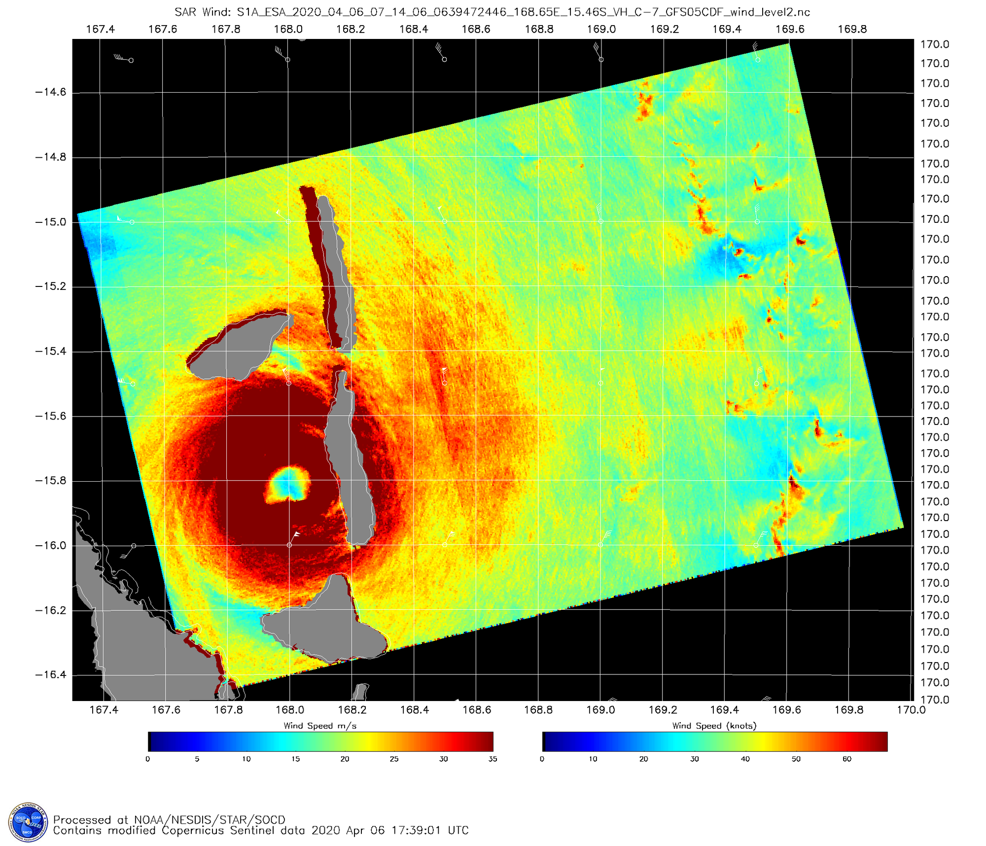
Figure 1. Synthetic Aperture Radar (SAR) image of Harold at 7:39Z April 6, 2020, as the cyclone was about to make landfall on Vanuatu’s Pentecost Island. The SAR instrument was estimating that Harold was a category 5 storm with 175 mph winds at the time. Credit: NOAA
Harold delivers a punishing blow to Vanuatu
On supporting science journalism
If you're enjoying this article, consider supporting our award-winning journalism by subscribing. By purchasing a subscription you are helping to ensure the future of impactful stories about the discoveries and ideas shaping our world today.
Tropical Cyclone Harold made landfall on the southwest coast of the island of Espiritu Santo (population 40,000) at 0Z Monday (11 am local time) as a category 4 storm with top sustained 1-minute average winds of 130 mph. The stronger northern eyewall of Harold passed over the island’s largest city, Luganville (pop. 16,000) near 2Z Monday (1 pm local time). Fortunately, Harold’s eyewall missed Efete Island, including Vanuatu’s capital city, Port Vila.
The rugged terrain of Espiritu Santo weakened Harold for a few hours, but the storm took advantage of moderate wind shear near 10 knots and very warm sea surface temperatures of 28-29°C (84-86°F) to re-intensify dramatically, passing over the south end of Pentecost Island (population 17,000) near 8Z. Officially, Harold was a high-end category 4 storm with 155 mph winds at 6Z, but some satellite intensity estimates suggested it was even stronger by 8Z, and the island likely experienced extreme category 5 damage.
Harold’s deadliest impact thus far occurred while it was a 40-mph tropical storm on Friday, when it produced strong winds and rough seas that affected a ferry crossing Iron Bottom Sound south of the Solomon Islands. The rough seas sent 27 passengers overboard from the ferry; five bodies had been found as of Sunday, with 22 people still missing.

Figure 2. Infrared Himawari-8 image of Tropical Cyclone Harold at 7:50Z April 6, 2020. At the time, Harold was passing over the southern end of Pentecost Island of Vanuatu as a high-end category 4 storm with 155 mph winds. Credit: NOAA and CIRA
Forecast for Harold
Harold was weakening on Monday afternoon, and the storm is expected to pass well to the south of Fiji’s two main islands on Wednesday as a category 3 or 4 storm. However, Harold’s eyewall could affect Fiji’s outlying Kadavu Island (population 10,000) on Wednesday. The island nation of Tonga will be at risk of receiving hurricane-force winds on Thursday, when Harold is likely to still be at least a Category 3 storm.
Harold the second strongest cyclone in Vanuatu’s history
The last category 5 storm to affect Vanuatu--and their strongest storm on record—was Tropical Cyclone Pam of 2015, whose top winds of 175 mph made it the third strongest tropical cyclone on record for the Southeast Pacific. Pam moved southward across several of Vanuatu’s smaller islands while at peak strength on March 13, 2015, with the eyewall passing over the east side of Efate Island. Pam killed 11 people and caused $450 million (2015 USD) in damage, making it Vanuatu's most expensive disaster in history. Thousands of buildings on multiple islands were damaged or destroyed.
As detailed in an excellent post by Bob Henson at Weather Underground’s Category 6 blog, Harold is the first Category 4 or 5 storm on record to move across Espiritu Santo and Pentecost Islands. Two category 3 storms have affected those islands.
Since reliable satellite data for the Southeast Pacific became available in the 1980s, there have been fourteen category 5 storms in the basin, as classified by the JTWC. Harold is tied as the fourth-strongest storm on record in the basin, and is the strongest storm so late in the season. The only other Southeast Pacific category 5 storm in April was Tropical Cyclone Ita of 2014, which peaked with 160 mph winds. Here is a list of the Southeast Pacific’s category 5 storms:
2002, Zoe, 180 mph
2016, Winston, 180 mph
2015, Pam, 175 mph
2020, Harold, 165 mph
1998, Ron, 165 mph
2005, Olaf, 165 mph
1988, Anne, 160 mph
1992, Fran, 160 mph
1998, Susan, 160 mph
2004, Heta, 160 mph
2005, Percy, 160 mph
2010, Ului, 160 mph
2014, Ita, 160 mph
Harold is the first category 5 storm in the southern Hemisphere since Tropical Cyclone Marcus of 2018, which intensified on March 21, 2018 to a category 5 storm with 175 mph winds and a central pressure of 905 mb off the northwest coast of Australia. The strongest southern hemisphere storm of 2019 was Cyclone Ambali in the Southwest Indian Ocean, which fell just short of reaching category 5 strength, topping out as a high-end category 4 storm with 155 mph winds.
Earth averaged 5.3 Category 5 storms per year between 1990 and 2019, according to ratings made by NOAA's National Hurricane Center and the U.S. Navy's Joint Typhoon Warning Center; five category 5 storms were observed in 2019.
Pandemic concerns
Vanuatu had no confirmed cases of the coronavirus as of Sunday, according to Reuters, but a state of emergency was declared for the nation on March 26 and domestic air travel was suspended on March 30 in preparation for the pandemic. The close-packed nature of refugee camps can make them perfect incubators for the spread of disease, and a COVID-19 outbreak will be a major concern in the aftermath of Harold--particularly as relief workers from the outside who might be carrying the virus arrive. Hopefully, a repeat of the tragic case of Haiti in 2010 can be avoided. In the aftermath of the great Haiti earthquake, UN peacekeepers from Nepal brought cholera, spawning a devastating 9-year outbreak that killed over 9000 people. The outbreak finally ended in 2019, it appears.