This article was published in Scientific American’s former blog network and reflects the views of the author, not necessarily those of Scientific American
Every few years throughout my childhood my family would pack up the car and make the multi-state drive down to a campground near Myrtle Beach, South Carolina. In the camp store – along with the marshmallows and shells in glass jars – there was a framed side-by-side photo on the wall. The two aerial shots of nearby neighborhoods showed the serene streets and houses before Hurricane Hugo and the barely recognizable devastation after. That picture always came to mind when storm clouds started to gather over the beach and shook our pop-up camper. It also came to mind when we were driving along a stretch of the Outer Banks, the trip going on so long that we started singing about “This is the road that doesn’t end; it just goes on and on my friend…” Casually one of my parents brought up the idea of trying to evacuate from the island before a storm, and that long road became a lot more intimidating.
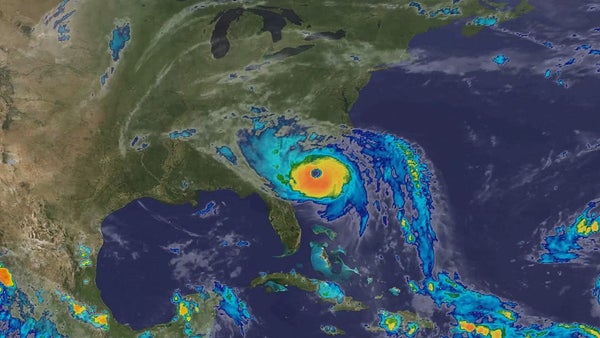
With all the news of Florence, I couldn’t help thinking about those side-by-side photos again. Then a space scientist friend of mine commented about how fortunate we are to have so much high-quality, space-based data to monitor and prepare people for storms, and it made me wonder how much had actually changed. Almost anyone who wanted to could monitor Florence in near-real time. I could call up weather radar on my phone. I could scroll around maps to see road closures and traffic jams on potential routes near my uncle’s house. It isn’t just that we have better satellites and instruments providing scientific data, it’s that most of Florence’s potential evacuees were carrying satellite receivers in their pockets or in their cars: GPS. That certainly wasn’t the case in 1989.
In 1989, people with home computers had Atari ST, Commodore 64, or early Macintosh. Mobile phones cost thousands of dollars and could barely last an hour. Coordinating an evacuation is a marvel of logistics, regardless of decade. Based on estimated vehicle counts, Hugo evacuations accounted for ~59% of the available vehicles in Charleston and 71% in Beaufort. With more cars and more people, preparing for Florence took city planners, engineers, government officials, scientists, public health specialists, law enforcement, and more.
On supporting science journalism
If you're enjoying this article, consider supporting our award-winning journalism by subscribing. By purchasing a subscription you are helping to ensure the future of impactful stories about the discoveries and ideas shaping our world today.
Creating a plan depends on understanding not just the storm, but the people who need to move. Surveys taken after Hugo showed a huge disconnect between how people believed they would react and how they actually did. Before Hugo, 40-50% of people said they would leave if a hurricane watch was issued, even if officials had not ordered an evacuation. But actual responses showed that only 10-15% had left before the official notices were ordered. Some of the traffic issues with Hugo arose because more people left town, and fewer headed to shelters, than expected.
Reading through reports from the months after Hugo provided insight not just into how protocols have changed, but how much more data-saturated everyday life has become. One analysis mentioned that “fax connections to local governments and conference call capabilities would have facilitated the NWS office’s ability to interact with local officials” and highlighted the inclusion of probabilities in their reports starting in 1983. A NOAA report recommended “Beef-up phone book materials and inserts that can be used in a real time event.” In among the statistics about evacuation times and flood maps in that report, there were statements about the models being updated by “marine advisories being fed directly into the program every 3 to 6 hours.” Every 3 to 6 hours seems unimaginable now. Data about evacuation times were collected from “discussions with local emergency and law enforcement officials in each area.” At the time, the handling of the event was heralded as cutting edge.
While some news stories praised the high-tech handling of the situation, post-storm analyses pitted their intended use against their perceived value. One analysis stated, “Graphical tools and computer software were employed in some locations to facilitate the computations. None of the tools appeared to have been used very effectively in most locations to assess forecast uncertainties, however, and some users had gross misconceptions about the tasks performed by the aids.” Later it mentions, “Users were generally pleased with the computer software available to them, but in many locations it was more a device for impressing elected officials and the media than for sophisticated decision making.” Combine that with the statement from a NOAA report that “Officials like the ability to show decision makers a ‘computerized’ data based that ties together ‘Technical Data Report’ information.” It recommends making “More camera ready/computerized mapping of surge areas, routes, and shelter locations for media.”
But even as much as we know, and as early as we know it, getting information to the right people in the right format is still a challenge. Evacuations from Florence started days earlier than Hugo, in part because of the work of the people studying that earlier event. One researcher said of Hugo, “It should also be noted that the worst of Hugo did not hit the populated locations of Beaufort, Charleston, or Myrtle Beach. If such had been the case, 20% to 30% of the homes in the inundated areas of those locations would have flooded with occupants still in them. Although evacuation notices were timely they were disseminated successfully only in the most hazardous beachfront and island locations.” In other words, part of their success was luck. Additional technology, better communication, and more aggressive timelines can translate past luck into a future plan – if the tools are used correctly and people take the time to listen.