
More Magnificent Mount Saint Helens Photos for Your Viewing Pleasure

We continue our journey through the USGS database full of delicious Mount Saint Helens photos

This article was published in Scientific American’s former blog network and reflects the views of the author, not necessarily those of Scientific American


I'm still going through the USGS image database for Mount St. Helens. It's going to take me a while - there are almost two thousand images to sort, catalog, and save. I'm sharing some of the best of what I find on Facebook: I'll be sharing them here, too!

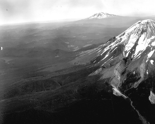
Really magnificent pre-eruption photo of Mount St. Helens. Definitely enlarge this. You'll see some fabulous glacial geology, inverted topography, old lava domes, and Mount Adams. Drooling now. Definitely click for the full image.

Black and white image shows Mount St. Helens at the extreme right. The most prominent feature is a glacier descending from the summit, and a deep valley it carved almost all the way down the slope in colder times. Looking towards Mount Rainier in the distance, there are several ridges that look like valleys that lava flows once flowed down; the surrounding, softer material has since eroded away. Mount Rainier is visible in the background on the right.
Pre-eruption aerial view northeastward of Mount St. Helens in the foreground, Mount Rainer in background. Image and caption courtesy USGS.


On supporting science journalism

If you're enjoying this article, consider supporting our award-winning journalism by subscribing. By purchasing a subscription you are helping to ensure the future of impactful stories about the discoveries and ideas shaping our world today.


None

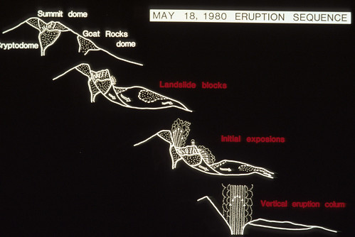
Here's a nice visual explanation of the May 18th eruption.

Image is a series of white line drawings on a black background, going from top left to bottom right. The first shows Mount St. Helens just before the eruption, and marks the locations of the summit dome, the cryptodome beneath it, and Goat Rocks dome on the side. The second picture shows Goat Rocks and the Cryptodome each coming down in its own landslide block. The third picture shows the landslide blocks reaching the valley, and the initial explosions emerging from the top and the side. The final drawing shows the landslide blocks resting on the valley floor, and the vertical eruption column rising from the remnants of the volcano.
Simple diagram by J.G. Moore showing Mount St. Helens eruption sequence of May 18, 1980. Skamania, County, Washington. Image and caption courtesy USGS.

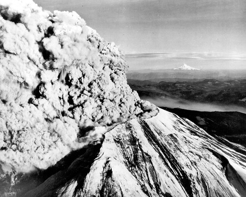
For my Oregon peeps: Mount St. Helens in eruption, with Mount Hood in the background.

Black and white image shows the new summit of Mount St. Helens from the northwest. You can see part of the notch the landslide and lateral blast left. A huge eruption column is pouring out of the top and bending northward. The flanks of the summit are streaked gray and black. In the distance, Mount Hood is a white triangle - its pointy top is quite distinctive.
Mount St. Helens in eruption, looking toward the southeast on May 18, 1980, with snow-covered Mount Hood on the distant horizon. Skamania County, Washington.

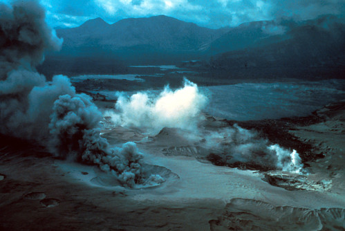
Eerie photo taken right after the May 18th eruption. We're looking across Spirit Lake. In the foreground, steam bursts from fumaroles in the blast deposits.

Image is looking across a plain of volcanic deposits towards mountains in the background. Everything is dark and gloomy except for the brilliant white steam plumes emerging from a crevasse in the foreground deposits. There is a crater with dark gray ash roiling from it in the center front: the ash plume is being blown toward the back left of the photo by the wind. Just beyond the plumes, scattered patches of dark water are visible in the destruction: the new Spirit Lake.
Oblique aerial view across Spirit Lake after the eruption of Mount St. Helens; secondary steam fumaroles in blast area in foreground. Skamania County, Washington. 1980. Image and caption courtesy USGS.

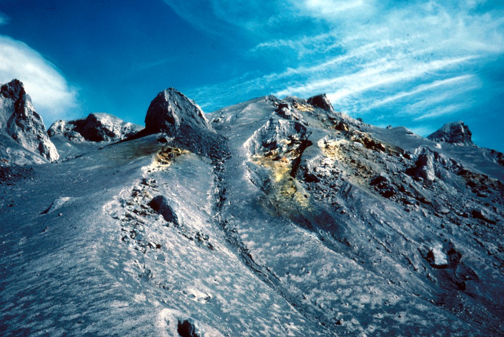
Absolutely gorgeous image of fumaroles on a pyroclastic flow from May 18 1980.

Image is taken from the base of a steep slope of mottled gray and light gray volcanic deposits, rising to a crest with boulders sticking out. Erosion has begun to cut shallow ravines int he slopes. Near the top, there are patches of harvest yellow where fumaroles have deposited sulfur: the color really pops against all that gray. The sky is deep blue with a few wispy white clouds.
Fumaroles on pyroclastic flow of May 18 eruption of Mount St. Helens. Skamania County, Washington. June 1, 1980.

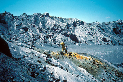
This is a rather gorgeous fumarole on a pyroclastic deposit from the May 18 eruption, with geologists for scale. You know, catastrophic destruction makes for magnificent landscapes.

Image shows an amphitheater ringed by rocky gray ridges. There is a touch of orange in the rim of the far ridge. In the foreground, another, lower ridge is topped with a streak of yellow-orange. Two geologists stand on top of the long orange deposit, looking down into the smooth volcanic ash scattered with logs. One has his hands on his hips.
Fumaroles and geologists on pyroclastic flow of May 18 eruption of Mount St. Helens. Skamania County, Washington. July 1, 1980. Image and caption courtesy USGS.

Geologists watching the August 7th, 1980 eruption. Dunno about you, but I'd have to spend a lot of time and effort screwing my courage to the sticking-place before I'd be able to stand there filming the volcano going boom after what it did in May.

Image shows Mount St. Helens in the near distance from directly to the north, erupting a thick plume of grayish-tan ash. Two geologists stand on the ridge in front of it, filming the eruption. One is kneeling, one is standing. A case of open equipment sits between them.
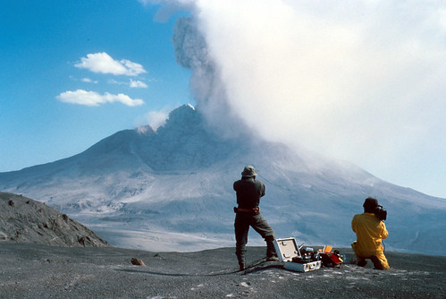
Time lapse of August 7, 1980, eruption of Mount St. Helens. Geologist in foreground for scale. Skamania County, Washington. Image and caption courtesy USGS.

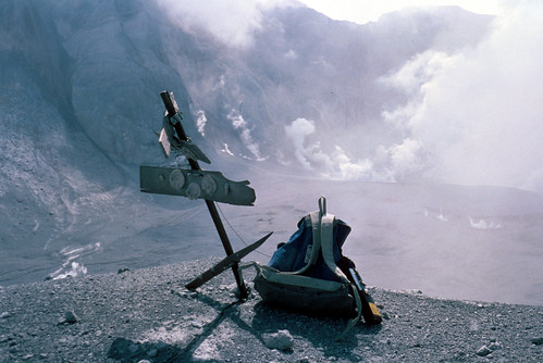
Eruptions are quite rough on volcano monitoring equipment. This is Kid Valley geodetic target after the eruption above got through with it.

Image shows a very bedraggled target: basically a post with boards nailed horizontally to it, with round reflectors attached to the boards. The top board is knocked askew and half-torn off. A chunk has been torn off the right side of the bottom board. Someone has left a backpack beside the target. In the background is a valley filled with volcanic deposits, and tall craggy ridges stripped of all life. Steam rises from the base of the ridges.
Kid Valley geodetic target after August 7 eruption of Mount St. Helens. Skamania County, Washington. August 9, 1980. Image and caption courtesy USGS.

Here's a really lovely image from May 19th, 1982. You can see that Mount St. Helens hasn't quite gone back to sleep yet. Photo is by Lyn Topinka, who has taken many marvelous pictures of that volcano. You'll see more of her work as we go along.

Image shows a snow-shrouded Mount St. Helens reflected in the calm waters of Spirit Lake. A plume of steam rises from the center of her crater: the top of it has been blown by the wind into anvil-shaped clouds close to the summit. The sky is a cloudless dark blue.
Mount St. Helens reflected in Spirit Lake, two years after the eruption of May 18, 1980. Skamania County, Washington. May 19, 1982. Photograph by Lyn Topinka. Image and caption courtesy USGS.

I'll have more lovely photos from before, during, and after May 18th, 1980. I've also got some non-volcanic adventures planned for this month. We're going to be venturing into geology quite different from the young stuff around Western Washington. Stay tuned!