This article was published in Scientific American’s former blog network and reflects the views of the author, not necessarily those of Scientific American
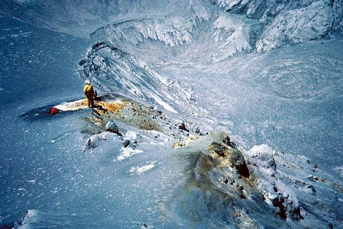
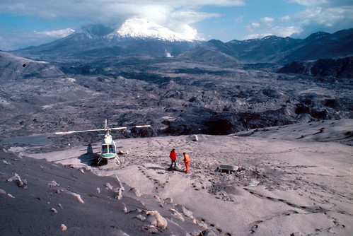
Love this view across a pyroclastic flow and a fumarole, looking into a depression. With everything living dead and buried, the geologist looks like an astronaut on a different planet.
On supporting science journalism
If you're enjoying this article, consider supporting our award-winning journalism by subscribing. By purchasing a subscription you are helping to ensure the future of impactful stories about the discoveries and ideas shaping our world today.
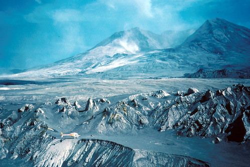
Mount St. Helens viewed from across a pyroclastic flow shortly after the May 18 eruption. There's a helicopter in there, too.
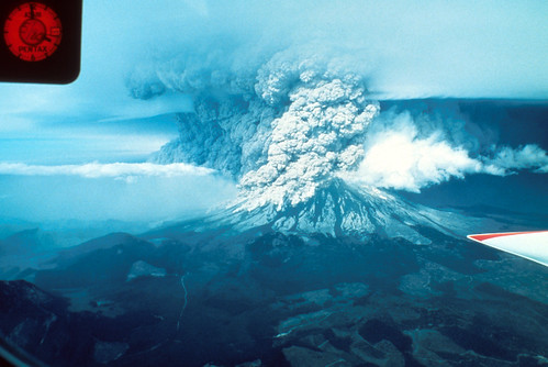
So, we're used to the usual Plinian eruption columns. You know, nice vertical ones that rise far up into the atmosphere and look all suitably impressive. But when a sector collapse leaves a huge notch in the new crater rim, stuff goes sideways. This image shows the resulting wall of ash roaring away to the north. Bloody amazing.
This is what it looks like after a volcano hurls ash all over your house. Stuff is an absolute disaster to clean up.

- Eastern Washington resident sweeping ash from the May 18, 1980 eruption of Mount St. Helens from the roof of his house. Washington. After May 18, 1980. Lower photo, page 17 in U.S. Geological Survey. Eruptions of Mount St. Helens: Past, Present, and Future by Robert I. Tilling. 1984. Public domain image and caption courtesy USGS.
Here's a lovely little before-and-after for ye. This is the North Toutle Bridge near A1 Rought Park. You can see it's a rather substantial metal thing - or at least it was, before a lahar hit it. You may have to zoom in to see its twisted remains in all that mud.

- Before-and-after composite of two USGS images: Left: North Toutle Bridge near A1 Rought Park before May 18 eruption of Mount St. Helens. View to north. Photo by D.R. Crandell. Cowlitz County, Washington. April, 1980. Right: Al Rought bridge after May 18 eruption of Mount St. Helens. Photo by D.R. Crandell. Cowlitz County, Washington. May 24, 1980. Public Domain images and captions courtesy USGS.
Since y'all love seeing what eruptions do to vehicles, have a look at what Mount St. Helens did to this Weyerhauser bus.
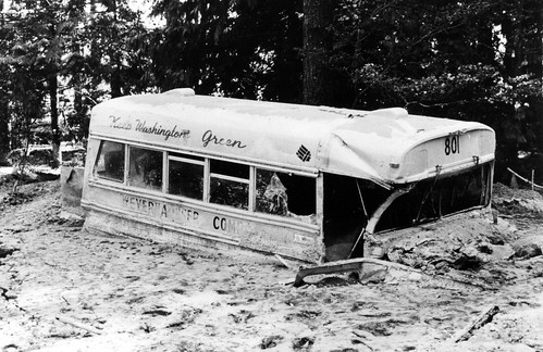
- Weyerhaeuser Company employee bus heavily damaged by May 18 eruption of Mount St. Helens and partially buried by mudflow on the North Fork Toutle River near Camp Baker. Bus was unoccupied when hit by the mudflow. Cowlitz County, Washington. 1980. Figure 409, U.S. Geological Survey Professional paper 1250. Public domain image and caption courtesy USGS.
OOOO neato. People, it's not often we get to see faults forming across our own footprints, but here we are!
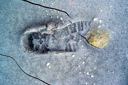
- Cracks forming before an eruption of Mount St. Helens. Footprint made on January 9, 1981 was cracked several days later. Footprint is right in front of a thrust fault. Skamania County, Washington. January 1981. Public domain image and caption courtesy USGS.
That's all for this edition, but stay tuned - I have so many more!