This article was published in Scientific American’s former blog network and reflects the views of the author, not necessarily those of Scientific American
One of the most dreaded impacts of climate change is gradual sea level rise. As carbon dioxide and other greenhouse gases accumulate in the atmosphere, they drive global temperatures to increase and cause water that was traditionally frozen in ice formations to melt and migrate to the oceans.
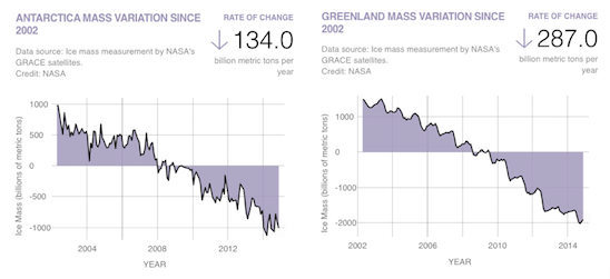
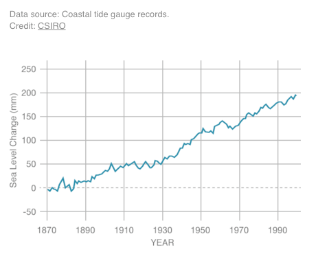
At the same time, rising global temperatures warm the ocean surface and cause the overall volume of water to increase due to thermal expansion. The result is an increase in the global average sea level caused by a combination of melting ice and expanding waters.
On supporting science journalism
If you're enjoying this article, consider supporting our award-winning journalism by subscribing. By purchasing a subscription you are helping to ensure the future of impactful stories about the discoveries and ideas shaping our world today.
While the rising trend in the average global sea level is well established, it turns out there is actually significant variation in sea level rise that has been observed in specific locations across North America. While sea level is rising across most of the continental United States, sea levels are actually falling on average in areas of the Pacific Northwest, Canada, and Alaska. Why? Because as ice melts away from the Arctic, there is less and less mass compressing the earth underneath, and it rebounds not unlike a coiled spring. Undersea tectonic motion can also contribute to variations in sea level rise.
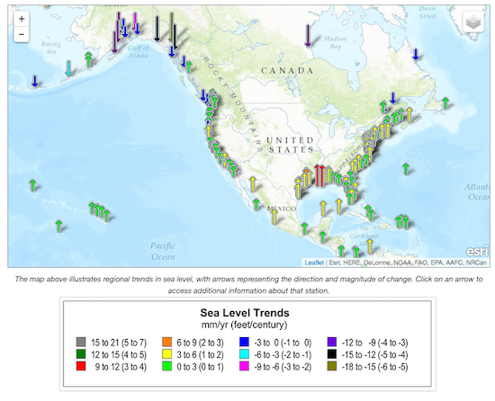
Source: NOAA
With more that 50 percent of the U.S. population living along the coast, it’s important to project how sea levels will change over the next century in specific geographic locations, so that governments and residents can plan accordingly. Fortunately, the U.S. Army Corps of Engineers has developed a tool that can be used to project future sea level rise at hundreds of different coastal gauges maintained by the National Oceanic and Atmospheric Administration (NOAA).
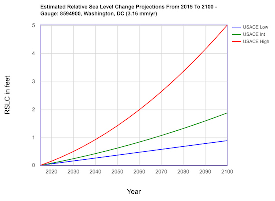
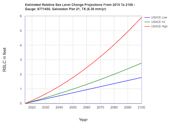
Want to see how sea level will change in your backyard? Simply select the closest NOAA gauge from the dropdown on this page and the tool outputs a low, intermediate, and high estimate of future sea level change. The low estimate assumes continued sea level rise at rates observed over the last hundred years, while the intermediate and high estimates correspond to accelerating rates predicted by the National Research Council.
Curves for two places close to home for me — Washington, DC and Galveston, TX — are shown below. Sea level stands to rise 0.88 to 5 feet in Washington, DC and 1.78 to 5.91 feet in Galveston by the end of the century. How much will sea levels rise in your backyard?
Agenda image credit: Flickr user Lenny K Photography via Creative Commons.